


|
||

|

|
|

|
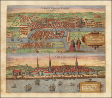
Rare early plan of St Petersburg, engraved by G.I. Unvertzagt and published by the Academy of Sciences in St Petersburg, 25 years after St. Petersburg became the Capital of Imperial Russia.
The map includes a 98 point key in Russian and German at the bottom identifying important locations on the map, and a vignette in the top left hand corner surmounted by the Romanov eagle and symbolizing the artistic, scientific and military prowess ol the new Russian capital.
In 1703, a site at the head of the Gulf of Finland, was selected by Czar Peter the Great to be the place on which a new capital city for the Russian Empire was to be built. Peter pressed a massive labor force of serfs to build the city, and no expense was spared. Leading architects and artisans from across Europe were offered large salaries to dedicate themselves to the task. The overall project came to be overseen by the French landscape architect, Jean-Baptiste Alexandre Le Blonde, who had previously served Louis XIV, who was ably assisted by the Swiss architect Domenico Trezzini.
Most of the city was planned to be built on Vasilyevsky Island, that lay within the mouth of the Neva River. The island was to be bisected by a series of canals and streets that were to follow a grid, which in places were to contain massive squares. On the south bank was the Admiralty district and on an island on the north bank, above Vasilyevsky Island, was the St. Peter & Paul Fortress. One might remark that much of the city resembles a series of gardens, and this is, in good part, due to the fact that Le Blonde's signature passion was designing gardens.
In spite of the massive resources thrown at the project, the original plan was greatly altered as work progressed. Vasilyevsky Island was proven to be too low-lying and prone to flooding to permit the creation of the canals, nor was it viewed appropriate as the site of the main town. While the area would eventually be built-up (later in the 18th Century) with streets largely following the lines of the proposed grid of canals, the main part of the city was built in the area which lay to the south of the Neva.
The first printed map to depict a version of the Le Blonde-Trezzini plan was Nicolas De Fer's Plan de la Nouvelle Ville de Petersbourg (Paris, 1717). With some modifications, this was followed by Johann Baptist Homann's map of St. Petersburg, published circa 1720.
The map was separately issued, but also occasionally added as an additional map in J.N. De L'Isle's Russischer Atlas : Welcher in einer General-Charte und neunzehen Special-Charten das gesamte Russische Reich und dessen angraentzende Laender, nach den Regeln der Erd-Beschreibung und den ne Academie der Wissenschafften, published in St. Petersburg, in 1745.
![Moscovia Parte Orientale . . . [with] Parte Occidentale . . .](https://storage.googleapis.com/raremaps/img/small/26615.jpg)