|
||

|

|
|

|
Governor Addison Gibb's Copy of The First Map to Show The Gold Regions In Southern Oregon At the Outset of the Oregon Gold Rush.
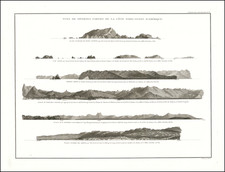
Highly important early map of Southern Oregon and Northern California, prepared by Nathan Scholfield shortly after the discovery of gold in Southern Oregon in the second half of 1850. Dated June 1851, the map provides a landmark advance in the mapping of the region, most notably between the Klamath River and the Umpqua River, the site of Scholfield's most active exploration as part of the Klamath Explorating Expedition. The map is perhaps most remarkable for being the first map to depict the gold regions of Southern Oregon, the new settlements along the Umpquah River, and the various rivers, topography and trails in the region.
Further to the south, Schofield also includes significant details of the Gold Regions in California, including the mines on the Feather River and its tributaries, extending as far south as Stockton. The early mining regions along the American River and its various forks are noted, with early towns such as Boston, Vernon, Fremont, Murphys, Mormon Is., Georgetown, Natoma, Leidsdorf, Nickolaus, Kearney, Oro, Plumas, Eliza, Linda, Marysville, Winslow, and Yuba City named. Nappa (Napa) and Sonoma are also shown north of San Pablo Bay.
The present example of the map bears the name "Mr Gibbs, Gardiner," on the verso, almost certainly being Addison C. Gibbs, an early Oregon settler and future Governor of Oregon. As described below, Scholfield and Gibbs almost certainly met each other during Scholfield's time in Oregon and their involvement in the early settlement of the region would have almost certainly dictated that Scholfield would have sent a copy of the map to Gibbs shortly after it was printed in June 1851.
Scholfield's map is a landmark in the history of the mapping of region, representing a combination of Scholfield's first hand knowledge of the area gained during his time as surveyor for the Klamath Exploring Expedition and the best available information of the region which preceded his surveying work in 1850. Scholfield and his son were hired as the surveyors for an expedition of gold seekers and land speculators in the second half of 1850, which resulted in the first exploration and survey of the lower Umpqua River Valley. He diligently synthesized his efforts with the maps of Fremont, Wilkes and others into a useful and comprenhensive mapping of the region. Streeter noted:
This is the first map of what is now Oregon to be lithographed west of the Rockies, and is one of the first, if not the first to show the new town of Portland, the new settlements on the Umpqua, and the road to California up the Willamette Valley. This and the Butler map, San Francisco, 1851 (copy in TWS), are among the few maps of California, lithographed there in 1850 and 1851 which have survived.
Scholfield's map was first advertised for sale in the Daily Atla California on June 11, 1851:
PIONEER BOOK STORE- Just published a new map of Southern Oregon and Northern California, compiled from the best authorities and from personal surveys and explorations, exhibiting a reliable view of the gold region as well as the mineral region of Middle California, embracing also a corrected chart of the coast from San Francisco Bay to Columbia river, agreeably to the United States Coast Survey, by N. Schoefield [sic], C. E. The author of this map has spent much line in exploring and surveying these portions of the country, and it is presumed to be more accurate and reliable than any other yet published.
MARVIN & HITCHCOCK, Montgomery st., near Clay
Notice of the map and a letter from Nathan Scholfield detailing his participation in the expedition which led to the founding of the first settlements in the lower Umpqua River Valley were printed in the Daily Alta California on June 13, 1851:
New Map.- We have received from Mr. Nathan Scholfield, Civil Engineer, a lithographic map of Southern Oregon and Northern California, compiled from the best authorities and from personal observations and explorations. It also embraces a corrected chart of the coast between San Francisco and the Columbia river. The map is published by Marvin & Hitchcock. Mr. S. does not pretend to perfect accuracy in all the details, but presents it as an approximate map, correct in all its main features. We subjoin a communication from the author relative to the result of his explorations, knowing that everything which relates to the Pacific coast is of interest to our readers. He differs in his opinions respecting certain localities from others who have made explorations and laid the results before the public.
San Francisco, June 13. 1851. Gentlemen - Accompanying this I send you a map of Southern Oregon and Northern California, composing a portion of the country lying between 40 and 44 degrees north latitude, which has till recently been but very little known; all previous maps of this portion being very erroneous and not to be depended on. Having spent considerable time in surveying and exploring this, as well other portions embraced in this map, I am enabled to present the public with an approximate map, without pretending to perfect accuracy in all its detail, yet in all its main features it may be relied on as correct. One year since it was not known where the Trinity river entered the ocean, or whether it was tributary to some other river. Parties of miners endeavored to have it done; but on account of the numerous falls and rapids and the precipitancy of its banks, it was not easily effected; others attempted by cruising along the coast, to find its entrance, and ascend it from its mouth; but this had hardly been accomplished when a party with whom I acted, set out to explore the Klamath river and valley. And for that purpose, with the maps of Fremont, Wilkes, and several others, we sailed for a point on the coast in latitude 42 deg. 22 min., where, according to these maps, the Klamath was made to enter the ocean. Here we found a river, but not such a one as we were led to expect; and after exploring it we ascertained that this was not the Klamath. but the Teutonis or Rogue's river which, by all our authorities, was made a tributary of the Klamath. We ascertained that the Klamath passed south, here it was joined by the Trinity, and then pursued its course to the ocean. Having satisfied ourselves of the general worthlessness of this river or any in its vicinity, as a channel of communication with the interior, on account of the numerous rapids and high precipitous banks, running even into mountains, we left it in possession of the barbarous savages who infest it, and bent our sails for the Umpqua river. Here, contrary to our expectations, we found an excellent harbor, spacious and well protected, with sufficient depth of water for vessels of large class, although in the language of Commander Wilkes, of the United States exploring expedition, we were led to suppose the "Umpqua afforded no harbor for seagoing vessels, and that there was but nine feet water on the bar." But we found eighteen feet on the bar at extreme low water, the same as at Columbia river, and a fine river, navigable for thirty miles to the head of tide water, and opening into a fine agricultural country in the interior. After thoroughly exploring this river, and tracing its meanderings as well as its several tributaries, and seeing the former maps were, in important points, very defective and erroneous, I deemed it expedient that a new one should be constructed, representing the main features of the country. I therefore offer this map to the public as the best representation of the country, till such time as the government surveys are completed. In addition to my own surveys, I have consulted in its construction the best maps extant, and the explorations and travels of scientific persons and miners, from which sources I have derived much valuable information. And lastly I have availed myself of the results of the late United States Coast Survey, by which I am enabled to give a corrected chart of the coast from San Francisco Bay to the Columbia river.
Yours, respectfully, N. Scholfield.
Nathan Scholfield and his son Socrates Scholfield were hired to serve as surveyors for the Klamath Exploring Expedition, an expedition of 35 gold seekers and land speculators which sailed north from San Francisco in May 1850 aboard the schooner Samuel Roberts, to explore the region around the Rogue River. The ship's captain and owner was Albert Lyman, whose manuscript journal of the expedition can be found in the Nathan Scholfield papers at Oregon State University). Also aboard were a young Canadian named Peter Mackie and an Englishman named Samuel E. Smith (both of whom assisted with the sailing duties). In addition to the Scholfields, others on the Expedition included Heman Winchester, Dr. Henry Payne, Dr. E. R. Fiske, S. S. Mann, Dr. J. W. Drew, C.T. Hopkins, Henry H. Woodward, Anthony Ten Eyck, A.G. Able, James K. Kelly, and others identified only with last names of Barney, Woodbury, Dean, Tierman, Evans and Knight.
As noted by Scholfield, the expedition proceeded north first to the Rogue River and then on to the Umpqua River. After a brief expedition by Canoe into the river, the Samuel Roberts crossed the bar and entered the Umpqua River on August 7, 1850, where the party discovered a group of Oregonians who were also exploring the Umqua region for gold, one of which, Levi Scott, having already taken a claim 26 miles upriver at what would become Scottsburg. Several smaller groups were created among the expedition members and each set out on the river and its tributaries, scouting out a total of 4 sites for future settlements, in consultation with the two Scholfields. After traveling up river as far as Fort Umpqua and Elkton, Oregon, the party returned to San Francisco.
Some of the original expedition members organized the Umpqua Townsite and Colonization Land Company, to exploit the townsites laid out, and by September 12, 1850, a second group of about 100 gold seekers and speculators was headed back north aboard the brig Kate Heath, which including Addison C. Gibbs. By October, 1850, the Umpqua Company was selling lots and ready to begin operations in Oregon. By this time, the operations of the Umpqua Company were headed up by Addison C.Gibbs, who joined the members of the expedition, purchased shares, and became its president.
The plans of Oregon land speculators were foiled when Congress passed the Donation Land Act of 1850. The Act provided free land only for actual settlers and their families - not for speculators from California. Gibbs continued forward, laying out the town of Gardiner in the first part of 1851 on a Donation Land Claim 7 miles above the mouth of the Umpqua River, where he would reside for several years.
Gibbs would soon thereafter be elected to the Oregon legislature (1851-52), and, when Gardiner was made a port of entry, Gibbs became collector of customs for the Southern District of Oregon. His manuscript Notes on the History of Oregon, is one of the most important early histories of the Territory and was acquired by Hubert Howes Bancroft (it now resides in the Bancroft Library at UC Berkeley).
As noted above, the present example of the map includes an annotation on the verso: "Mr Gibbs / Gardiner," indicating that the map was almost certainly owned by Gibbs, who would become known as the Wartime Governor of Oregon (second governor of Oregon, 1862-1866). After establishing the town of Gardiner, In 1853, he volunteered for service in the Rogue River Indian War, later serving as a commissioner for the Rogue River Indian Claims. From 1853-1857, Addison served the Umpqua district as a representative in the territorial legislature and as a customs collector.
Given Scholfield's connection to the Umpqua Company, it would have been highly likely that shortly after the first printing of the map in San Francisco, Scholfield would have forwarded a copy of the map to Gibbs in his newly created town of Gardiner. The use of the name Gardiner, rather than Gardiner's City, is consistent with the title on the map and offers further evidence that its transmission to Gibbs likely pre-dated the opening of the post office in Gardiner's City.
Gardiner is located on the Umpqua River in Douglas County, Oregon. Gardiner is named for the owner of a Boston merchant whose ship, the Bostonian, was wrecked at the mouth of the Umpqua on October 1, 1850, with the salvage of merchandise and wood from the ship going to Gardiner and to Scottsburg.
Nathan Scholfield (1806-1858) was born and raised in Connecticut. He was a trained machinist, civil engineer and inventor. He travelled to California with his son Socrates in 1850 and later to Oregon, where he conducted survey work and bought land.
The map is one of the earliest maps printed in San Francisco, printed by the firm of Marvin & Hitchcock. J.W. Hartman, the lithograher, is among the earliest lithographers working in San Francisco. Peters notes only one item ( Map of Northern California. Exhibiting a reliable view of the Rich Gold Region. By N. Schofield, C.E., Lith. by J.W. Hartman, San Francisco...Entered 1851). Peters comments: "This is possibly the Hartman of Zakreski & Hartman. I have but one lithograph by Hartman."
OCLC lists 4 examples of the map (Yale, Huntington, Oregon Historical Society and UC Santa Cruz).
![Chart of the Coast of California from San Blas to San Francisco Drawn chiefly from the Spanish Surveys, the Charts of Vancouver &c. the whole much improved by recent observations made by English and French Naval Officers . . . 1854 [Additions to 1862]](https://storage.googleapis.com/raremaps/img/small/58999.jpg)
![[Imperial & Coachella Valley Advertising Map -- Valerie Jean Date Shop]](https://storage.googleapis.com/raremaps/img/small/69651.jpg)
![Central Valley Project -- California [Map and Views of California]](https://storage.googleapis.com/raremaps/img/small/91596.jpg)
![[ Southern California to Grand Canyon / Boulder Dam ] Inexpensive Sky Tours via Western Air Express](https://storage.googleapis.com/raremaps/img/small/76820.jpg)