
This item has been sold, but you can enter your email address to be notified if another example becomes available.


|
||

|

|
|

|
Stock# 40546
Description
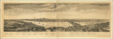
Scarce map of London, based upon the Ralph Agas view of London, published in 1563.
This is a retrospective map of Elizabethan London, giving us an idea of how people in the late 18th century viewed the Elizabethan capital. The present-day Covent Garden is an area of fields named "Convent Garden", indicating that the area belonged to the Abbey of St Peter's at Westminster before the dissolution of monasteries in the reign of Henry VIII.
The location of Tower Bridge is marked, although the actual bridge was not planned until 1879. This indicates that Londoners were thinking about bridging the river at this point one hundred years before the decisive plan to do so.
Key includes the names of 10 important locations.
Condition Description
Trimmed a bit at the top of image.

![Regionis, quae est circa Londinum specialis repraesentatio geographica, ex autographo majori Londinensi . . . 1741 [Includes Bird's-eye View of London and Westminster]](https://storage.googleapis.com/raremaps/img/small/95041.jpg)