
This item has been sold, but you can enter your email address to be notified if another example becomes available.


|
||

|

|
|

|
Stock# 40518
Description
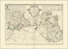
Detailed map of Alaska, the Northwest Coast of America and Northeast Coast of Asia, showing the exploration tracks of Captain James Cook's 2 expeditions though the region in the spring and summer of 1778 and 1779.
Beginning in area north of Vancouver Island, the tracks follow the coastline in a northwesterly direction, before turning southwest and following the Aleutian Archipelago (not yet named) and then turning northward toward the arctic circle.
Condition Description
Minor restoration at lower right margin, including reinstatement of a small part of the neat line.

![[Unique Extra-Illustrated Example!] Carte Nouvelle Contenant La Partie d'Amerique La Plus Septentrionale, . . . Le Canada ou Nouvelle France, La Nouvelle Ecosse, La Nouvelle Angleterre, Les Nouveau Pais Bas, La Pensylvanie . . . Et Jle. de Terre Neuve . . .](https://storage.googleapis.com/raremaps/img/small/47720.jpg)