|
||

|

|
|

|
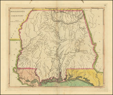
An important early map of the State of Mississippi, by Carey & Lea.
This interesting map, issued in 1822, shows Mississippi only 5 years after the state entered the Union on December 10, 1817. At this time, only a southern third of the state had been settled by Americans of Eureopan origin, while much of the northern two-thirds were still the lands of the Chickasaw and Chacktaw Native American nations. Jackson, the state capital, lay right on the northern edge of the settled area. The vast native lands are traversed only by the 'Road from Pierrce River to Nashville' and 'General Jackson's Road from New Orelans to Muscle Shoals', the latter made by the U.S. Army during the Creek War (1813-14).
The present map appeared as part of Henry Carey & Isaac Lea's A Complete Historical, Chronological, and Geographical American Atlas (Philadelphia, 1822). It included many important early state maps, along with detailed written decriptions of the present state and history of the states. Carey & Lea were part of the venerable firm, Carey & Sons, the first great American map publishing house, established by Henry's father Matthew Carey in the 1780s.
This map is one of the critical foundation maps of any collection of the cartography of Mississippi.
Isaac Lea (1792-1886) was an American publisher and geologist. Raised a Quaker in Delaware, he turned away from pacifist teachings and joined the militia in the War of 1812. After marrying Frances Anne, the daughter of publishing magnate Mathew Carey, Lea became a junior partner of Carey & Son in 1822. Mathew Carey left the firm in the same year and Isaac Lea worked primarily with his brother-in-law, Henry Charles Carey.
The pair conducted business as Carey & Lea, during which time they published A Complete Historical, Chronological and Geographical Atlas from 1822 to 1827. This work included roughly twenty maps engraved by Fielding Lucas Jr., as well as an American edition of Starling’s Cabinet Atlas. However, the firm increasingly turned away from cartographic publications.
By 1829, after the brief participation of Edward Carey, Henry’s younger brother, the company became known as Carey & Lea. William A. Blanchard joined the firm in 1833, causing another name change to Carey, Lea & Blanchard. Henry retired in 1838, leaving the firm as Lea & Blanchard.
Isaac Lea was not just a publisher, but an avid researcher with aptitude for geology. He was a member of the American Academy of Natural Sciences and the American Philosophical Society. He retired from publishing in 1851 and turned increasingly to geological research, results of which he published until his death in 1886.


![(The First Letter From British Florida) [September 5, 1763, Autograph Letter, Signed, from Robert Campbell to John Campbell, 4th Earl of Loudoun, describing the British taking possession of Florida and the state of the settlement of Pensacola]](https://storage.googleapis.com/raremaps/img/small/86620.jpg)