|
||

|

|
|

|
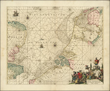
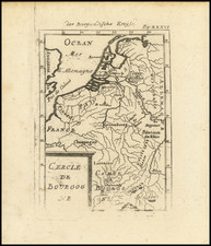
Rare variant edition of Frans Hogenberg's map of the seat of war in Flanders during the 80 Years War, published at the conclusion of the Spanish siege of the Ostend.
Between 1601 and 1604, the Spanish besieged Ostend. The Dutch, losing 20,000 men during the siege, fared better than the Spanish, who lost as many as 60,000 men, due to casualties or disease. While the siege was under way both England and France negotiated peace terms with the Spanish, thereby leaving the Dutch alone in their struggle against the Spanish. The States General ordered Ostend to surrender on September 20, 1604. Prior to the surrender, the Dutch captured Sluys and all the ships in the harbor.
The present example does not include the text below the image, which has been maked off by the printer.
In his 1903 Catalogue, the famous bookseller Frederick Muller (Topographie de l'Europe: Catalogue à prix marqués de cartes anciennes . . . item 1062), lists the map as "Carte tres curieuse et tres rare." (Very interesting and very rare map).
Frans Hogenberg (ca. 1540-ca. 1590) was a Flemish and German engraver and mapmaker who also painted. He was born in Mechelen, south of Antwerp, the son of wood engraver and etcher Nicolas Hogenberg. Together with his father, brother (Remigius), uncle, and cousins, Frans was one member of a prominent artistic family in the Netherlands.
During the 1550s, Frans worked in Antwerp with the famous mapmaker Abraham Ortelius. There, he engraved the maps for Ortelius’ groundbreaking first atlas, published in Antwerp in 1570, along with Johannes van Deotecum and Ambrosius and Ferdinand Arsenius. It is suspected he engraved the title page as well. Later, Ortelius supported Hogenberg with information for a different project, the Civitates orbis terrarium (edited by Georg Braun, engraved by Hogenberg, published in six volumes, Cologne, 1572-1617). Hogenberg engraved the majority of the work’s 546 prospects and views.
It is possible that Frans spent some time in England while fleeing from religious persecution, but he was living and working in Cologne by 1580. That is the city where he died around 1590. In addition to his maps, he is known for his historical allegories and portraits. His brother, Remigius, also went on to some fame as an engraver, and he died around the same time as his brother.
![[Holland] Holad](https://storage.googleapis.com/raremaps/img/small/78197.jpg)