|
||

|

|
|

|
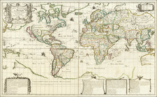
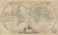
Striking example of Hubert Jaillot's final double hemishpere map of the World, published in Amsterdam, in 1706.
The map shows California as an island. The unknown southern continent appears, along with a partial New Zealand and Australia. The map also includes the mythical land bridge between Japan and the West Coast of North America, and early Great Lakes projection.
Fine decorative image, surmounted by a French Royal Coat of Arms.
Alexis-Hubert Jaillot (ca. 1632-1712) was one of the most important French cartographers of the seventeenth century. Jaillot traveled to Paris with his brother, Simon, in 1657, hoping to take advantage of Louis XIV's call to the artists and scientists of France to settle and work in Paris. Originally a sculptor, he married the daughter of Nicholas Berey, Jeanne Berey, in 1664, and went into partnership with Nicholas Sanson's sons. Beginning in 1669, he re-engraved and often enlarged many of Sanson's maps, filling in the gap left by the destruction of the Blaeu's printing establishment in 1672.
![Charte über die verschiedenen jezt auf der Erde herrschenden Religionen [Map on the various religions now ruling the earth]](https://storage.googleapis.com/raremaps/img/small/85202.jpg)