The item illustrated and described below is sold, but we
have another example in stock. To view the example which
is currently being offered for sale, click the
"View Details" button below.
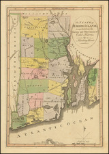
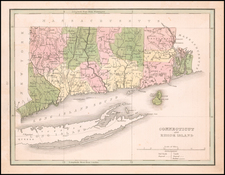
1814 Mathew Carey
$ 475.00


|
||

|

|
|

|
Stock# 39666
Description
Important early map of Rhode Island, from Carey's American Atlas, one of the earliest separate maps of Rhode Island printed in the US.
Includes towns, travel routes, topographical detail and waterways shown. Carey published his American Atlas in 1795, which became the first folio atlas published in America.
He became the first American publisher to offer hand coloring.
Condition Description
Bottom right border trimmed to the neat line.