|
||

|

|
|

|
Stock# 39584
Description
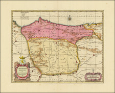
Nice example of Wagenhaer's map of the Spanish Coastline, from Cape de. Ortegal in the east, to Monte Louro and Cape Finisterre in the west, centered on Coruna, Malpica de Brigantinos and Ferrol.
Lucas Wagenhaer was a Dutch pilot who produced the first set of effective navigational charts, under the title Spiegel der Zeevaerdt. These gorgeous charts, engraved by Baptist and Jan van Doetecum, embody the latest contemporary knowledge of navigation and position finding, and set the standard which was followed for more than a century. Waghenaer's charts are magnificent works of art, which are highly sought after by collectors.
An essential map for collectors of the region and the earliest decorative sea chart of the region.