|
||

|

|
|

|
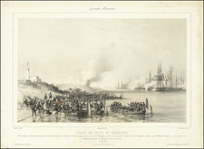
Fine set of plans of the strategic military strongholds near the Straits of Gibraltar.
The set includes a total of 9 maps and views, including:
- The Straits of Gibraltar and southern tip of Spain, from Cadiz and Marbella in the north to Gibraltar and Tarissa in the south.
- The Gibraltar Peninsula and fortifications
- A view of Gibraltar
- The Island of Minorca
- The Harbor at Cadiz
- The fortifications at Cueta.
- A view of Tanger from the Sea.
- A View of Tanger from Land.
- A view of Cadiz
The main map shows a battle off the coast of Cape Trafalgar.
Johann Baptist Homann (1663-1724) was a mapmaker who founded the famous Homann Heirs publishing company. He lived his entire life in Bavaria, particularly in Nuremberg. Initially, Johann trained to become a priest before converting to Protestantism and working as a notary.
In 1702, Johann founded a publishing house that specialized in engravings. The firm flourished, becoming the leading map publisher in Germany and an important entity in the European map market. In 1715, Johann was named Imperial Geographer to the Holy Roman Empire by Charles VI and made a member of the Prussian Academy of Sciences. Most importantly for his business, his reputation and contacts gained him imperial printing privileges which protected his publications and recommended him to customers. Johann is best known for this Grosser Atlas ueber die ganze Welt, or the Grand Atlas of the World, published in 1716.
After Johann died in 1724, the business passed to his son, Christoph (1703-1730). Upon Christoph’s early death, the company passed to subsequent heirs, with the name of the company changing to Homann Erben, or Homann Heirs. The firm continued in business until 1848.
![Questo e Il vero disegno de Tunis con gran parte de lafrica tratto da un disegno fatto al tempo che Il Serenissimo Imperator Carlo V lo prese lan[n]o 1535 co[n] le distancie delle terre piu Jmportante.](https://storage.googleapis.com/raremaps/img/small/61570sb.jpg)