![(First World War - Seriocomic) Европа въ 1915 г. [Europe in 1915] By Anonymous](https://storage.googleapis.com/raremaps/img/small/98679.jpg)


|
||

|

|
|

|
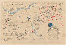
Rare satirical war map of Europe, published in Paris.
According to London Map Dealer Tim Bryars, the map is based upon a Polish map, " giving the Russian take on things. " Bryars notes:
This 'Symbolic map of Europe' was [first] published in Warsaw by Vladislav Levinsky, passed by censor on 9 April 1915 and (naturally enough, having been passed by censor…) it tows the official line. Many caricature maps show Poland struggling to be free, but Poland had been partitioned for more than a century when this map was made, and Warsaw was then the third largest city in the Russian Empire. The map is dominated by the serene figure of the Tsar, pinking the raging German bull without physical exertion of any kind. . . . The Tsar himself is the personification of Russia, and the Tsar himself will bring victory.
A version of the map was also published in Paris (by 'Editions G-D' as 'Carte Symbolique de l'Europe … Guerre Liberatrice de 1914-1915'. The signature is the same, but dated 1914; the French edition may indeed have primacy, as our map is described as 2nd edition, top right) and this French connection may explain the contrast between a glamorous Marianne riding a fine specimen of a cockerel and the rather dowdy battle-axe in battleship grey which represents Britannia. I like Ireland, keeping company in some sort of fishing smack! The cartoonist is fairly kind to the countries on the periphery of the map. Russia's neutral neighbours, Sweden and Norway, are portrayed as two beautiful women in a close embrace (enduring stereotypes again?) but in another break from the maps we've seen so far the Austro-Hungarian Empire is not represented by anything living at all, man or beast. Instead, a fallen crown lies on a barren plain, spotted with graves, bringing us full circle to the predictions of Louis Raemaekers and the fall of empires.
timbryars.tumblr.com/post/14824179535/satirical-maps-of-the-great-war-1914-1915
![[ Through Cooperation to Communism ] Spolupraci ke Komunismu](https://storage.googleapis.com/raremaps/img/small/97646.jpg)