![[ Grodno / Hrodna, Belarus ] Vera Designatio Urbis In Littavia Grodnae By Georg Braun & Frans Hogenberg](https://storage.googleapis.com/raremaps/img/small/96900.jpg)


|
||

|

|
|

|
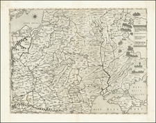
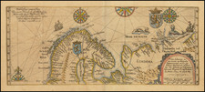
Striking old colored example of Braun & Hogenberg's view of Hrodna or Grodno, Belarus, from an early edition of Braun & Hogenberg's Civitates Orbis Terrarum.
This finely engraved view shows the city from across the Memel. Russian, Tatar, Turkish and Wallachian envoys are crossing the wooden bridge and entering the city in which King Sigismund II held an Imperial Diet in 1562. The earliest document in which Grodno is mentioned dates from 1128. In 1391, it was granted a municipal charter by Prince Vytautas and it quickly rose to prosperity following the victory over the Teutonic Knights in the battle of Tannenberg in 1410; Orthodox (right) and Roman Catholic (left) churches were built, and three castles (left).
Includes a decorative coat of arms. Shows the city on the far side of the Neman River, with a wooden bridge crossing the river. Buildings and chapels rest on the tops of hills, while men on horseback parade through the streets. The text on the verso translates as follows:
Lithuania is a vast but uncultivated land, east of Poland, with much grassland and marshes. The episcopal city of Vilnius is the capital and it is as big as Cracow with all its suburbs. The next biggest is Grodno, which lies on the River Cronon, or Memel, partly in the plain and partly on hilly ground. There are only a few stone houses standing together, the houses are roughly built, with little care; the city also has no walls or towers, gates and fortifications. But nearby there is a castle and a royal palace on the mountain, there the king of Poland has his seat.
Georg Braun (1541-1622) was born and died in Cologne. His primary vocation was as Catholic cleric; he spent thirty-seven years as canon and dean at the church St. Maria ad Gradus, in Cologne. Braun was the chief editor of the Civitates orbis terrarum, the greatest book of town views ever published. His job entailed hiring artists, acquiring source material for the maps and views, and writing the text. In this role, he was assisted by Abraham Ortelius. Braun lived into his 80s, and he was the only member of the original team to witness the publication of the sixth volume in 1617.
Frans Hogenberg (ca. 1540-ca. 1590) was a Flemish and German engraver and mapmaker who also painted. He was born in Mechelen, south of Antwerp, the son of wood engraver and etcher Nicolas Hogenberg. Together with his father, brother (Remigius), uncle, and cousins, Frans was one member of a prominent artistic family in the Netherlands.
During the 1550s, Frans worked in Antwerp with the famous mapmaker Abraham Ortelius. There, he engraved the maps for Ortelius’ groundbreaking first atlas, published in Antwerp in 1570, along with Johannes van Deotecum and Ambrosius and Ferdinand Arsenius. It is suspected he engraved the title page as well. Later, Ortelius supported Hogenberg with information for a different project, the Civitates orbis terrarium (edited by Georg Braun, engraved by Hogenberg, published in six volumes, Cologne, 1572-1617). Hogenberg engraved the majority of the work’s 546 prospects and views.
It is possible that Frans spent some time in England while fleeing from religious persecution, but he was living and working in Cologne by 1580. That is the city where he died around 1590. In addition to his maps, he is known for his historical allegories and portraits. His brother, Remigius, also went on to some fame as an engraver, and he died around the same time as his brother.