


|
||

|

|
|

|
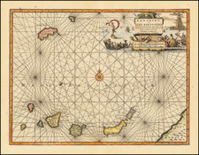
Nice example of this early state of Barent Langenes's map of Terceira, in the Azores, which first appeared in the 1598 edition of Langenes's Caert-Thresoor, published in Middelburg.
The present map is one of the earliest obtainable maps of Terceira.
Langenes's map was first issued in his Caert-Thresoor and later re-published in by Bertius, in his Tabularum Geographicarum, beginning in 1600, with the total number of appearances of this map running to no less than 12 appearances between 1598 and 1650, in the two works by Langenes and Bertius .
Barent Langenes was a Dutch publisher and engraver at the turn of the seventeenth century. He worked in Middleburg, Netherlands. He is best known for his publication of Petrus Bertius’ Caert-Thresoor in 1598. This pocket world atlas was small, printed in the vernacular, and was more affordable than folio-sized competitors, allowing more people to own and use atlases. The atlas was a commercial success and was printed twelve times in Dutch, French, Latin, and German editions between 1598 and 1650, although Langenes was most likely only involved in the first two Dutch editions (1598 and 1599).
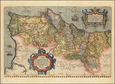
![[ Portugal ] Portugalliae Que Olim Lusitania, Novissima et Exactissima Descrtiption Auctore Vernando Alvaro Secco . . . 1600](https://storage.googleapis.com/raremaps/img/small/103381.jpg)