


|
||

|

|
|

|
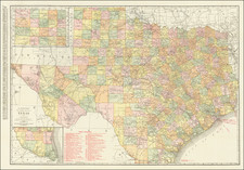
Detailed map of Texas, colored by counties and showing the primitive county configurations in the west.
Based upon De Cordova's seminal map. Illustrates many early roads, towns, forts, and other important places. An excellent pre-Civil War map. From the scarce 1859 edition of Colton's atlas, which is the first to include the imprint of Johnson & Browning, one year before these two publishers created their own New Illustrated Family Atlas of the World.
Jacob De Cordova (1808 - 1868) was one of the first major land speculators in Texas. He hired Robert Creuzbaur, of the Texas General Land Office, to compile this map for promotional purposes. It was the first map of the state to be constructed through the use of the files of the Land Office. The Land Office was responsible for keeping a record of all land transactions in the state, though De Cordova is said to have spent a great deal of time in the saddle, personally studying Texas real estate. The land office was especially important, as Texas had been allowed to keep its public lands when it entered the Union, the only state allowed to do so, and the Land Office records were the only reasonably accurate source for the topography of some 250 million acres in the public domain. Creuzbaur gave equal attention to the more settled eastern parts of the state, and the map is the best, most detailed record of settlement in Texas during the period. Measuring nearly three feet square, it was the first large-scale map of Texas.
De Cordova's map was originally published in Houston in 1849, with subsequent Houston editions issued in 1851, 1853, and 1854. Publication rights were subsequently sold to J. H. Colton, who published editions in New York from 1856 onwards. This 1861 edition is the best cartographic record of Texas at the beginning of the Civil War. It incorporates extensive revisions, with new counties, towns, railroads, roads, and topographical detail, particularly in the little-known western parts of the state.
R. S. Martin noted that without question, "the map published by Jacob De Cordova in 1849 best summarizes the geographical information available about Texas immediately after the Mexican War...the map presents a remarkably accurate and detailed rendering of the area south and east of San Antonio." But north and west of that point, however, "the data are scarce and the features sparse." However, the later editions were carefully revised to account for new information, particularly in West Texas, and it is this fact which makes them so valuable.
G. W. & C. B. Colton was a prominent family firm of mapmakers who were leaders in the American map trade in the nineteenth century. Its founder, Joseph Hutchins Colton (1800-1893), was a Massachusetts native. Colton did not start in the map trade; rather, he worked in a general store from 1816 to 1829 and then as a night clerk at the United States Post Office in Hartford, Connecticut. By 1830, he was in New York City, where he set up his publishing business a year later.
The first printed item with his imprint is dated 1833, a reprint of S. Stiles & Company’s edition of David Burr’s map of the state of New York. He also printed John Disturnell’s map of New York City in 1833. Colton’s next cartographic venture was in 1835, when he acquired the rights to John Farmer’s seminal maps of Michigan and Wisconsin. Another early and important Colton work is his Topographical Map of the City and County of New York and the Adjacent Country (1836). In 1839, Colton began issuing the Western Tourist and Emigrant’s Guide, which was originally issued by J. Calvin Smith.
During this first decade, Colton did not have a resident map engraver; he relied upon copyrights purchased from other map makers, most often S. Stiles & Company, and later Stiles, Sherman & Smith. Smith was a charter member of the American Geographical and Statistical Society, as was John Disturnell. This connection would bear fruit for Colton during the early period in his career, helping him to acquire the rights to several important maps. By 1850, the Colton firm was one of the primary publishers of guidebooks and immigrant and railroad maps, known for the high-quality steel plate engravings with decorative borders and hand watercolors.
In 1846, Colton published Colton’s Map of the United States of America, British Possessions . . . his first venture into the wall map business. This work would be issued until 1884 and was the first of several successful wall maps issued by the firm, including collaborative works with D.G. Johnson. From the 1840s to 1855, the firm focused on the production of railroad maps. Later, it published a number of Civil War maps.
In 1855, Colton finally issued his first atlas, Colton’s Atlas of the World, issued in two volumes in 1855 and 1856. In 1857 the work was reduced to a single volume under the title of Colton’s General Atlas, which was published in largely the same format until 1888. It is in this work that George Woolworth (G. W.) Colton’s name appears for the first time.
Born in 1827 and lacking formal training as a mapmaker, G. W. joined his father’s business and would later help it to thrive. His brother Charles B. (C. B.) Colton would also join the firm. Beginning in 1859, the General Atlas gives credit to Johnson & Browning, a credit which disappears after 1860, when Johnson & Browning launched their own atlas venture, Johnson’s New Illustrated (Steel Plate) Family Atlas, which bears Colton’s name as the publisher in the 1860 and 1861 editions.
J.H. Colton also published a number of smaller atlases and school geographies, including his Atlas of America (1854-56), his Illustrated Cabinet Atlas (1859), Colton’s Condensed Cabinet Atlas of Descriptive Geography (1864) and Colton’s Quarto Atlas of the World (1865). From 1850 to the early 1890s, the firm also published several school atlases and pocket maps. The firm continued until the late 1890s, when it merged with a competitor and then ceased to trade under the name Colton.