|
||

|

|
|

|
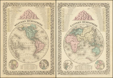
Striking pair of maps of the Eastern and Western Hemisphere, published in Edinburgh by John Thomson.
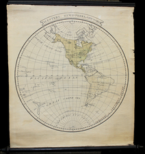
Includes tracks of the various 18th Century Explorers in the Western Pacific (Cook, Vancouver, La Perouse, etc.), along with excellent detail. The NW Coast of America is still largely conjectural. The cartography of the West is based upon Humboldt, pre-dating Lewis & Clark's information. Several fanciful mountain ranges appear, as does a lake surrounded by mountains, with no name. Interesting treatment of Alaska.
John Thomson (1777-ca. 1840) was a commercial map publisher active in Edinburgh. He specialized in guide books and atlases and is primarily known for his Atlas of Scotland (1832) and the New General Atlas, first published in 1817 and reissued for the next quarter century. The New General Atlas was a commercial success—it was also published in Dublin and London—and it compiled existing geographic knowledge in compelling ways for a wide audience.
His Atlas of Scotland introduced new geographic information and was the first large-scale atlas of Scotland to be organized by county. It provided the most-accurate view of Scotland available before the Clearances. Work on the atlas began in 1820 and led to Thomson’s bankruptcy in 1830 due to the high costs of gathering the latest surveys and reviewing the required materials. Despite the publication of the atlas, Thomson declared bankruptcy again in 1835.
![[17th Century Provenance!] Universalis Tabula Iuxta Ptolemaeum](https://storage.googleapis.com/raremaps/img/small/72635.jpg)