


|
||

|

|
|

|
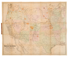
Fine example of Keeler's "National Map", one of the most influential maps of the American West published immediately following the conclusion of the Civil War, including the 30 page Notes to Accompany Keeler's Map of the U.S. Territory ....
The present example is inscribed by N.G. Taylor, Commissioner of the Bureau of Indian Affairs. to Lot Myrick Morrill, a Senator from Maine.
The map provides a monumental compilation of data from many governmental sources and is color coded to show the locations of Gold, Silver, Copper, Quicksilver, Iron and Coal. Completed and proposed railroad lines are shown, as are Land Offices, Forts and Military Posts.
Keeler's map has been described as the largest, finest and most detailed map of the West as it was then known. . "In 1867, seeking to take advantage of public interest in all aspects of the West, but particularly the railroad routes, William J. Keeler, an engineer working in the Indian Bureau, published a large, attractive map of the entire country west of the Mississippi. As a product no doubt of Keeler's own employment with the Indian Bureau, the various Indian reservations were clearly shown and identified by a color scheme, an early use of this thematic device." (Martin).
Keeler's map of the west is among the most important maps of the period. As noted by Wheat,
Keeler's map extends from Cincinnati to the Pacific, and from about the 32nd to the 42nd parallel--or frm Ft. Reno in Wyoming to Ft. Filmore in New Mexico; It has a superior showing of new military data, being in advance even of the Colton maps (for example, Ft. Fetterman on the upper North Platte, Camp Douglas near Great Salt Lake City, Ft. Reynolds, Ft. Morgan, and Ft. Sedgwick in Colorado). It also displays, with color symbols, deposits of gold, silver, coal, copper, and quick silver from eastern Colorado to California--information . . . economically pertinent to railroad operations. But primarily it is interesting for railraod routes west of the Missouri; The Union Pacific is shown completed as far as Fort D.A. Russell, near Cheyenne, the projected route then going past Ft. Sanders on the Larame, and past Ft. Hallbeck to Bitter Creek; alterations of the route made west of the Larmie by Dodge and his engineers in the summer of 1867 had not yet come to Keeler's attention. The route goes on by Echo Canyon to the Great Salt Lake Valley, then swings north around the lake to the Humboldt, somwhere in the stretch becoming the Central Pacific R.R. The latter, somewhat prematurely, is shown completed down the Truckee almost to the great bend of that river.
What appears on this map as the "U.P.R.W.E.D." is represented as completed all the way to Ft. Wallace, near the west edge of Kansas (That was the expectation of the Company in the summer of 1867). Just beyond, inside the Colorado line, this road branches,one route going northwesterly to Denver, the other southwesterly to Arkansas and the Purgatorie, thence to Ft. Union and Albuquerque, and on to California via the route later actually employed by the Atchison, Topeka & Santa Fe. From Albuquerque yet another line follows down the Rio Grande, with an extensive western branch turning off at Ft. McRae to seek out Californai via the Gila. This latter branch is not labelled. Keeler's railroad map is full of factual information, but is also full of hope and faith.
William Keeler's map of the Western US is regarded as a landmark in the mapping of the Western United States, providing the best detailed and comprehensive look at the Western Railroad System after the close of the Civil War. His large map was widely distributed and its influence on the history of the Mapping of the Transmississippi West is profound.
Lot Myrick Morrill (1813-1883) served as the 28th Governor of Maine, in the United States Senate and as Secretary of the Treasury appointed by President Ulysses S. Grant.
Morrill was elected Maine's House of Representatives in 1854 as a Democrat and served as Chairman of the Maine's Democratic Party. However, as the nation divided over slavery during the 1850s, Morrill's politics changed and he went over to the Republican Party opposed to the expansion of slavery. He was elected Maine's state senator in 1856 as a Republican, and elected Governor of Maine in 1858, serving until 1861 during the outbreak of the American Civil War. Morrill was elected Maine's U.S. Senator in 1861, when a vacancy was opened in the U.S. Senate, after Sen. Hannibal Hamlin assumed the office of Vice President under President Abraham Lincoln.
In 1876, Sen. Morrill was appointed U.S. Secretary of the Treasury by President Grant.
![Carte Qui Contient La Maniere Dont Se Fait La Chasse Des Bouefs Sauvages . . . [Buffalo, Niagara Falls, Calumet Village, Huron & Illinois Indians]](https://storage.googleapis.com/raremaps/img/small/93146.jpg)
![The Mother Lode of California [Guide to the Mother Lode Mariposa to Downieville]](https://storage.googleapis.com/raremaps/img/small/97535.jpg)
![[Imperial & Coachella Valley Advertising Map -- Valerie Jean Date Shop]](https://storage.googleapis.com/raremaps/img/small/69651.jpg)
![[The 13 United States] Charte uber die XIII vereinigte Staaten von Nord-America Entworfen duch F.L. Gussefeld . . . Ao 1784](https://storage.googleapis.com/raremaps/img/small/100144.jpg)