
The item illustrated and described below is sold, but we
have another example in stock. To view the example which
is currently being offered for sale, click the
"View Details" button below.


|
||

|

|
|

|
Stock# 38565pb
Description
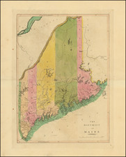
Gorgeous example of Carey's map of Maine, one of the best large format maps of Maine to appear prior to its becoming a state.
Six counties are shown. The northern regions are barely known, with no settlements and virtually no topographical information. In the south, the extensive lake and river systems are noted, along with towns, roads, bays, islands, shoals and other important features.
Carey's General Atlas first published in 1814 was the first American Atlas to be offered for sale with hand coloring on the maps.
![[ Large Cape Cod Inset ] The River & Gulf of St. Lawrence, Newfoundland, Nova Scotia, and The Banks Adjacent, From The English Admiralty & French Marine Surveys. . . . 1844. Additions To 1857.](https://storage.googleapis.com/raremaps/img/small/85637.jpg)

![Maine [showing disputed boundaries as claimed by US, New Brunswick, and as settled by the King of the Netherlands]](https://storage.googleapis.com/raremaps/img/small/71923.jpg)