
This item has been sold, but you can enter your email address to be notified if another example becomes available.


|
||

|

|
|

|
Stock# 38352
Description
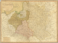
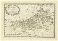
Rare separately issued map of Poland, with both historical borders (pre-1772) and modern boundaries, as of the publication date of the map.
The Polish flags and inset plan of Warsaw (Warschau) are quite unusual.
The title of the map translates as follows:
The land of Poland before its first division of 1772 and the present state since 1815. With allusions to contemporary events with availing of local distances and the names of the country Provinces limits...
A very ususual thematic island map. Tables includes:
- regional population statistics
- table of battles for the political independence
At the top right is a map of Warsaw surrounded by Polish flags and the words "To be or not to be," in German.
The map is apparently very rare. We located several advertisements for the map in the 1820s and 1830s but no modern auction records.
Condition Description
Some soiling and staining.
![[ Poland ] Poloniae Nova et Acurata Descriptio](https://storage.googleapis.com/raremaps/img/small/67711.jpg)