


|
||

|

|
|

|
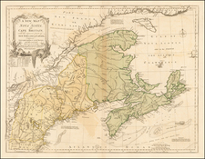
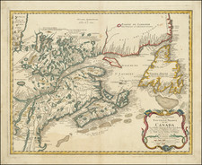
Foundational pre-French & Indian War map of eastern Canada, from Newfoundland to Lake Ontario and including the Northern portion of New England.
This finely engraved map embraces eastern Canada and northern New England and is focused on the River and Gulf of St. Lawrence, then the gateway to French North America. It is a revised and updated version of Bellin's map, which was first issued in Pierre Francois Xavier de Charlevoix's Histoire et Description Generale de Nouvelle France, published in Paris in 1744 (Kershaw has identified 4 editions of the map). Charlevoix was a Jesuit Priest who explored Canada and America's eastern regions between 1705-1720 and is widely regarded as the most important French exploration of the region in the second half of the 18th Century.
In this later edition, the map extends considerably further south and provides significantly updated cartographic detail in the western part of the map, incorporating Cape Cod, Rhode Island and a portion of upstate New York, along with fine coverage of Lake Champlain. The location of Lake Ontario is also moved further to the west in this edition, just off the map.
Importantly, this edition of the map was issued on the eve of the French & Indian War (or Seven Years' War, 1756-63). Bellin's projection was the finest published cartography available to both sides during the conflict and this region featured the decisive battles of the war.
Louisbourg, shown here on Isle Royale (Cape Breton Island), was a massive French fortress, built in 1720. The fort had earlier fallen to the British in 1745, before being returned to France in 1748. The bastion would be finally retaken by the British in 1758, opening Canada to invasion.
In 1759, the British would defeat the French at the Plains of Abraham, thus seizing Quebec City and ensuring Britain's conquest of New France.
Also shown is St. John's, the capital of Newfoundland, England's oldest colony (briefly seized by the French in 1762) and Port La Joie, the main French town of Isle St. Jean (Prince Edward Island). Further to the south is the key British naval base of Halifax (founded 1749) and the largest British city in the northeast, Boston.
The chart, compiled by Jacques-Nicolas Bellin (1703-72), the Hydrographer to Louis XV, was based on the finest available French sea charts and Jesuit maps of the interior. Bellin's manuscripts, on which the present chart is based, are today preserved at the Bibliotheque nationale de France (Paris). Bellin's map would remain the chart of record until Samuel Holland's scientific surveys were published as part of J.F.W. Des Barres Atlantic Neptune (London, 1775-84).
An anchor map for any collection of Canadian cartography.
Jacques-Nicolas Bellin (1703-1772) was among the most important mapmakers of the eighteenth century. In 1721, at only the age of 18, he was appointed Hydrographer to the French Navy. In August 1741, he became the first Ingénieur de la Marine of the Dépôt des cartes et plans de la Marine (the French Hydrographic Office) and was named Official Hydrographer of the French King.
During his term as Official Hydrographer, the Dépôt was the one of the most active centers for the production of sea charts and maps in Europe. Their output included a folio-format sea atlas of France, the Neptune Francois. He also produced a number of sea atlases of the world, including the Atlas Maritime and the Hydrographie Francaise. These gained fame and distinction all over Europe and were republished throughout the eighteenth and even in the nineteenth century.
Bellin also produced smaller format maps such as the 1764 Petit Atlas Maritime, containing 580 finely-detailed charts. He also contributed a number of maps for the 15-volume Histoire Generale des Voyages of Antoine François Prévost.
Bellin set a very high standard of workmanship and accuracy, cementing France's leading role in European cartography and geography during this period. Many of his maps were copied by other mapmakers across the continent.