The item illustrated and described below is sold, but we
have another example in stock. To view the example which
is currently being offered for sale, click the
"View Details" button below.

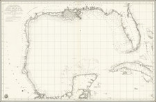
1720 Louis Renard
$ 2,700.00


|
||

|

|
|

|
Stock# 38192
Description
Finely colored example of De Wit's general sea chart of the southeastern United States, Gulf Coast, Florida and the Caribbean, offered here in an addition published by Renard.
The map is based upon Hessel Gerittsz's map of 1631, although it is based more closely on Lootsman's chart of 1661. The map was likely engraved by Romein de Hooghe.
There is a wealth of navigational information including sandbanks and shoals. The chart is a masterpiece of decorative engraving with illustrations of sailing vessels, a compass rose and two elaborate title cartouches (Latin and Dutch), one showing cannibalism.
The map was re-issued by both Renard and by Ottens in the early 18th Century.
Condition Description
Minor fold split at lower centerfold, repaired on verso. Just touching printed image.
Reference
Burden 468.