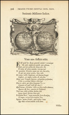
|
||

|

|
|

|
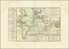
Finely colored two sheet map of the World, showing the tracts of Captain James Cook's three voyages, published in Vienna by Franz Schraembl, the leading mapmaker in Austria at the end of the 18th Century.
Includes dates of significant observations from Cook's journals. Excellent detail in the Pacific, Oceana, southeast Asia and along the northwest coast of America. The map is also among the earliest world maps to locate Hawaii, then known as the Sandwich Islands.
The map avoids showing a definitive Northwest Passage, one of the few maps to show such restraint.
Schraembl was born and worked in Vienna, where he was a mapmaker in the latter half of the eighteenth century. He began his business in 1787, partnering with Franz Johann Joseph von Reilly. He is best known for his large format atlas, the Allgemeiner Grosser Atlas. The atlas was finished in 1800, after twenty years of compilation and composition--it was the first Austrian world atlas. While a notable work, the atlas did not sell well, plunging Schraembl into financial difficulty. In response, Schraembl expanded his offerings to include literature and art. Upon his death, Schraembl's firm was taken over by his widow, Johanna, and her brother, Karl Robert Schindelmayer. From 1825, it was run by Franz Anton's son, Eduard.
![Tabula Terre Nove [The Admiral's Map]](https://storage.googleapis.com/raremaps/img/small/81714.jpg)
![(Second World War - Anti-British Propaganda) Français regardez cette carte [French, look at this map!]](https://storage.googleapis.com/raremaps/img/small/88492.jpg)
![[Hand Drawn Map of the World]](https://storage.googleapis.com/raremaps/img/small/86629.jpg)