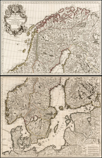
|
||

|

|
|

|
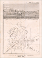
A detailed map of the St. Petersburg Governorate, printed in St. Petersburg by Alexey Afinogenovich Ilyin, one of the most important 19th Century maps of the region.
This fine lithographed map, with text in Cyrillic, shows the St. Petersburg Governorate. The city of St. Petersburg, located roughly in the center of the map, was then the capital and the second largest city in the Russian Empire, with a popilation of around 700,000. A detailed inset city plan is located in the lower right.
St. Petersburg was then one of the leading industrial centers in Europe and the nucleus of Russian culture, as this was the time of Ivan Turgenev and Fyodor Dostoyevsky, who brought Russian literature to the world. As shown on the map, the multitude of railways which had been built over the last generation, had revolutionized St. Peterburg's economy and made journeys that traditionally took days, last only a matter of hours. The first railway in Russia was built in 1837 between Saint Petersburg and the Czar's palace at Tsarskoye Selo, at a length of only 17km. In 1851, the Moscow-St. Petersburg railway was comlpleted, and following that, lines were built connecting the captial to Minsk, Helsinki and Talinn (and through that, Central Europe). This map is one of the first to show all of these new routes.
The map was printed as part of Alexey Afinogenovich Ilychin's Podrobnyi atlas Rossiiskoi imperii s planami glavnyh gorodov ('Detailed Atlas of the Russian Empire with Plans of the Major Cities'), published in St. Petersburg in 1871, which importantly was the only large atlas of Russia printed during the second half of the 19th Century. The atlas comprised 70 maps, including general maps representing all of Russia's provinces and regions, with plans of the most important cities. In addition, it included several thematic works, such as orohydrographical, ethnographical, administrative maps.
The publisher, The Cartographic Establishment of A. Ilyin was founded in 1859 by the General Staff officers Alexey Afinogenovich Ilyin (1832-1889) and Vladimir Poltoratsky (1830-1886). The firm was originally known as the Chromolithography of Poltoratsky, Ilyin and Co., but after Poltoratsky's departure in 1864, its name was changed to solely reflect Ilyin's stewardship. Alexey Ilyin served as cartographer for the Military Topographic Depot of the General Staff and was eventually promoted to the rank of Lieutenant-General. He thus had privileged access to government map archives, granting him a great competitive edge over his rivals. After the death of Alexey Afinogenovich, one of his sons, Alexey Alexeevich Ilyin (1857-1942) assumed control over the firm. By 1882, the enterpirse reached its zenith, producing up to 6 million impressions, accounting for around 90% of all civilian cartographic products published in Russia.
A essential piece for any collection of the mapping of St. Petersburg or of cartography made in Russia.
![Moscovia Parte Orientale . . . [with] Parte Occidentale . . .](https://storage.googleapis.com/raremaps/img/small/26615.jpg)
![[ Crimea ] Spezial Karte von dem Konigreich Taurien oder del Halbinsel Krim](https://storage.googleapis.com/raremaps/img/small/101372.jpg)