


|
||

|

|
|

|
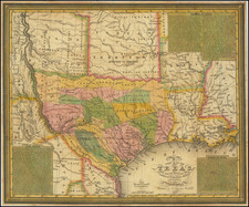
A fine example of Young & Mitchell's map, one of the truly great early maps of Texas, published in 1836, the year that Texas became the independent 'Lone Star Republic'.
This historically important and attractive map is the second issue of Young & Mitchell's A New Map of Texas, and is critically the first edition published following the independence of the Republic of Texas from Mexico. While the map does not specifically proclaim Texas's succession, it nevertheless shows it to be a clearly defined and separate political entity, traversed by the improvements of the Anglo-Texan colonists. The Young & Mitchell map is one of the earliest and most important elements of the founding cartographic sequence of Texas and features a wealth of information that makes it one of the most detailed and compelling contemporary depictions of the 'Lone Star Republic'.
In the early 1830s, the settlement of Texas and the rising tensions between the Anglo-Texan settlers and the Mexican government generated intense interest amongst the American public. The publication of Stephen Austin's groundbreaking Map of Texas (1830) sparked a great appetite for new maps and geographical information on the region. Austin's map was soon followed by David H. Burr's Texas (1833). The first issue of the Young & Mitchell's A New Map of Texas was issued in 1835, on the eve of Texas's independence, with seven subsequent editions issued up to 1845. It was largely based in Burr's map, but includes some notable improvements, including the correct delineation of the Sabine River, marking the border between Texas and Louisiana.
The Young & Mitchell Map in Focus
The most engaging aspect of the map is its detailed labeling if the numerous 'empresario' grants, or Anglo-American colonies that make up much of Texas, each distinguished by bright original colors. The most notable is 'Austin's Colony', the first such grant formed in 1821, and which had subsequently expanded to embrace a large territory in the heart of of the Republic. 'San Felipe de Austin', today's Austin, lies at the center of the colony, on the banks of the Colorado River. Originally founded as the village of Waterloo in 1837, it would eventually be renamed after Stephen Austin and would be designated as the republic's new capital in March 1839. Other important empresario colonies shown include 'De Witt's Grant', 'Whelin's Grant', 'Zavalla's Grant', 'Burnet's Grant' and 'Felisola's Grant', 'McMullen & McGlone's Grant', 'John Cameron's Grant' and 'Beale & Grant's Grant'. These lands would later be subdivided into counties, forming the modern civil foundation of Texas.
Several key settlements are labeled, including San Antonio de Bexar, the largest town in Texas, founded in 1718, and the site of the Battle of the Alamo, fought in February-March, 1836, where Texan Independence fighters made a heroic stand against the Mexican army. Others include Brazoria, Harrisburg (the first provisional capital of independent Texas, near the future site of Houston), Washington (called the "Birthplace of Texas", where delegates declared the independence of the republic on March 2, 1836) and Nacogdoches, site of the first Spanish settlement in Texas (1716). Also included on the map are the routes of numerous roads, as while some of the rivers were navigable, they were considered the lifeline of the Republic.
The depiction of the northern and western frontier regions is captivating. While the delineation of the upper Rio Grande is less than precise, the interior lands feature a wealth of information. As Texas claimed the entire upper east bank of the river, it labels the region "Santa Fe formerly New Mexico", as both the towns of Santa Fe and Taos lay within Texas's enlarged boundaries. Expanses of territory, clearly beyond the practical control of Texan authorities, are shown to be dominated by the "Apaches Mescaleros" and "Comanche Indians". Other areas are labeled as "elevated prairies" or home to "Droves of Wild Cattle & Horses". The future state of Oklahoma, north of the Red River, is shown to be 'Indian Territory', where the U.S. Government had recently exiled Native American Nations form the southeast during the 'Trail of Tears'. On the northern bank of the Red River is "Fort Towson", an important U.S. army outpost guarding the 'Permanent Indian Frontier'.
One will notice that the southern border of Texas, as shown on the map, runs along the Nueces River, to the north of the Rio Grande. This line was historically considered to be the southern frontier of Texas, however, during the War of Independence, the Texans expanded their claims southwards to the Rio Grande to embrace the so called 'Nueces Strip' or 'Wild horse Strip' (named after the Wild Horse Desert). While the Treaties of Velasco (May 14, 1836), which ended the war, recognized the Strip as henceforth belonging to Texas, the Mexican government subsequently disputed the concession. The controversy over the ownership of the Nueces Strip was used as a pretext by U.S. President James Polk to instigate the Mexican American War in 1845.
The map is further embellished with lengthy and very interesting notes on the current state of the Texas, included in three insets, entitled 'Remarks on Texas', 'Land Grants', and 'Rivers of Texas'. The remarks paint a highly favorable view of the region. As American sentiment heavily supported the Republic's independence (and the notion of Texas's future entry into the Union), the remarks are geared towards encouraging further Anglo American settlement in the region. Highlights include, in:
'Land Grants', it is noted that a settler can still acquire "50,000 acres at the minimum price of 10 dollars", an amazing deal, with no comparison in the United States. A guarantee is also given that "New settlers are exempt from the payment of the usual taxes for the term of 10 years."
'Remarks on Texas', the region is said to possess:
a geographical position highly favorable to commercial intercourse with the United States, and the rest of the world, are advantages which doubtless will at no distant period, render it an opulent and powerful State".? It also asserts that "Texas is one of the finest stock countries in the world. Cattle are raised in great abundance, and with but little trouble. Many of the settlers count their herds by hundreds, and great numbers are annually purchased, and driven to New Orleans by drovers, who visit the country for that purpose. The population is estimated at near 45,000 Americans and 4 or 5,000 Mexicans. [A note added to the map in 1835, before Texas's independence:] When the population shall be found to number 50,000, the people will endeavor to obtain a government separate from that of Cohahuila [sic], the establishment of a State legislature at San Felipe [Austin], and the right of electing their own representatives to the General Congress at Mexico.
"Rivers of Texas: notes that many of the main rivers are navigable for many miles and that the valley of the Brazos River features soils which are "the richest and deepest in Texas, and are considered equal in fertility to any in the world".
Historical Background
In 1821, 'Tejas' was a largely neglected frontier province of New Spain, which itself was gripped by the final throws of the revolution which would shortly establish Mexico's independence. The non-indigenous population numbered only 2,500, centered on a handful of missions and presidios, and development was hindered by the fierce resistant of Comanche and Apache warriors.
In the dying days of its hegemony, the Spanish regime granted concessions to foreigners, called 'empresarios' (Spanish for 'entrepreneurs'), to settle certain frontier regions, in order to act as bulwarks against the Native American peoples, provided that they met certain conditions. In 1821, Moses Austin became the first of the many Anglo-American empresarios, having agreed to settle 300 Catholic families along Texas's Brazos River. Moses died shortly thereafter and his title passed to his son, Stephen Austin (1793-1836), who was later widely regarded as the "Father of Texas".
The new Mexican Constitution of 1824, devolved powers to the individual states, although it also ordained that Texas was to be merged with a more populous state to the southwest, becoming part of the State of Coahuila y Tejas. This meant that the new regional base of power would be in faraway Saltillo or Monclova. Fortunately, the authorities in Coahuila generally showed themselves to be tolerant, if not supportive, of Anglo-American settlers, as they hoped such developments would secure their northern frontier and raise tax revenues.
Austin energetically set about attracting enterprising settlers to his colony, with the first wave of families, "the Old Three Hundred", arrived late in 1825. Over the rest of the decade, the territory of Austin's grant was progressively expanded, as he managed to attract a further 900 migrants. During the same period, other American empresarios founded colonies, as depicted on the present map. While conditions were challenging, most of these colonies succeeded in establishing permanent settlement. While technically all new immigrants were to swear allegiance to Mexico as citizens, be Roman Catholic, learn Spanish, and observe a prohibition on slavery, these stipulations were rarely enforced. Gradually, a new society Anglo-American developed, demographically and culturally distinct from the rest of Mexico.
Importantly, Stephen Austin, who had skillfully conducted his own surveys and acquired the best sources from other cartographers, completed his Map of Texas (1830), published by Henry S. Tanner in Philadelphia. This was the first comprehensive map of the region, and ran into several updated editions.
By 1830, the Anglo-American population of Texas reached 30,000, outnumbering the Mexican-born citizens by a factor of four to one. The Mexican government, perhaps rightly, feared that this demographic shift was a threat to its national security. President Anastasio Bustamante enacted the new laws of April 6, 1830, which effectively banned all foreign immigration to Texas. While Americans continued to arrive illegally, the Texan colonists and the Mexican government were now heading on a collision course.
It was during this period, that David H. Burr, the Geographer to the United States House of Representatives, updated Austin's work with a new map, Texas (New York, 1833), showing seventeen land grants. Burr's map was the first large-scale map of Texas to show all of the region extending to include the Arkansas River and the Texas Panhandle. Burr's map formed the basis for the Young and Mitchell map, although the latter included notable improvements.
In 1835, the conservative regime of President Antonio López de Santa Ana, announced plans to enact the 'Siete Leyes' (Seven Laws) which would dissolve the elected state governments and to impose direct federal rule over all of Mexico. As was the case in several other Mexican states, the Texans found these developments to be absolutely intolerable and in October of that year, commenced an armed rebellion against Mexican rule. This conflict was known as the War of Texan Independence.
The present second state of Young and Michell's A New Map of Texas (1836) was prepared as Texas's independence had been proclaimed and the rebellion was underway, but before the conflict had been concluded.
After an epic series of military campaigns, the Texan forces decisively defeated and captured Santa Ana at the Battle of San Jacinto on April 21, 1836. The Republic of Texas was born, with Santa Ana (who was then in Texan custody, having been captured at San Jacinto) recognizing Texan independence upon signing the Treaties of Velasco on May 14, 1836. While the Mexican government disavowed the treaties (claiming that they were singed under duress), Texas preserved it autonomy. The Mexican American War (1845-48) conclusively severed Texas from Mexico and Texas joined the Union as the 28th State.
The Mapmakers
The present map was designed and engraved by J. H. Young and published by S.A. Mitchell, a pairing that proved to be one of the most rewarding in the history of American cartography.
Samuel Augustus Mitchell (1792-1868) was the most prolific American map publisher of the 19th Century. Originally a school teacher, his frustration with the poor quality of educational maps led him to form his own mapmaking business. In 1830, he purchased the plates and rights to Anthony Finley's New American Atlas (1826) and hired J. H. Young, Finley's chief engraver, to improve and update the plates. He acquired the copyright for Henry S. Tanner's New Universal Atlas (1836) in 1845, and extended the life of the copperplates by having the images transferred to lithographic stone for printing. Mitchell was also a pioneer in the use of steel engraving, employing the technique in the early 1830s, almost 20 years before the general switch to steel (approximately 1850). Mitchell retired in 1860, turning the business over to his son Samuel Augustus Mitchell, Jr. The firm prospered until the 1890s.
James H. Young (fl. 1817-66) was an Irish-American cartographer, draftsman and engraver who played a leading role in the creation of 19th Century American maps and atlases. Based in Philadelphia, he was at various times associated with Anthony Finley, Charles Varle, William Kneass, George Delleker, and Samuel Augustus Mitchell, amongst others. His best-known works were the maps for Finley and later Mitchell's New American Atlas. While arguably the finest map engraver in America of his day, he was far more than an artisan, but also a knowledgeable and discerning editor of sources, and a designer of maps. Walter Ristow asserted that "Young was the [S.A. Mitchell] company's principal compiler and draftsman as well as chief engraver from 1830" until the 1860s. These varied skills were brilliantly displayed during the creation of the present map of Texas.
Young & Mitchell's A New Map of Texas, especially in the present first republican state, is one of the great monuments of Texan cartography, and an essential piece for any serious collection of Texana.
For over fifty years, Samuel Augustus Mitchell, his son, and his successors some of the most prominent publishers of maps and atlases in the United States. Samuel Augustus Mitchell Sr. was born in Bristol, Connecticut on March 20, 1792. His father had emigrated from Scotland in 1773. While little is known about his early schooling, it is known that Mitchell found the quality of early geography text books to be lacking, and determined that he would write and publish better works. This decision led him to relocate to Philadelphia in 1829 or 1830, which was then the center of commercial publishing in America.
Mitchell’s first cartographic work was the re-issue of Anthony Finley’s New American Atlas in 1831, a work first issued by Finley in 1826, in response to Henry Schenk Tanner’s monumental work of the same title, issued in serial format from 1818 to 1822 and as a complete work from 1823 onward. While the map content in Mitchell’s edition of the New American Atlas is the same as Finley’s edition, each map has been significantly improved and revised, primarily with the addition of new towns and roads. This is especially true in the south and west. Finley had originally collaborated with D.H. Vance and J.H. Young in the preparation of the maps, although Vance’s name is removed from the Mitchell edition. Mitchell continued to work with Young, an association which would continue for several decades.
Following publication of the New American Atlas, Mitchell began issuing the individual maps in pocket map format. From 1834, Mitchell began offering reduced sized Tourist Pocket Maps of a number of states in the United States. J.H. Young and D. Haines are listed as the engravers on these maps. In 1832, Mitchell offered the first edition of his Travellers Guide Through the United States, A Map of the Roads, Distances, Steam Boat & Canal Routes &c. By J.H. Young . . ., which would become one of his most popular and enduring works. The map of the United States was done by steel engraving, one of the earliest uses of the technique in map publishing in America. In the same year, the first edition of Mitchell’s Map of the United States, by J.H. Young was issued, bearing the copyright date of October 10, 1831. This map would be revised and issued until 1844. Young also compiled A New Map of the United States in 1833. These two wall maps would come to dominate the market and their success led to several later US wall maps issued by Mitchell. This second map was also issued under the title of Mitchell’s Reference and Distance Map of the United States, which was printed until 1851.
Mitchell was neither a cartographer nor an engraver. His primary function was as the editor and business manager of his publishing company, with Young working as the primary maker of maps. Beginning in 1839, Mitchell also began publication of his school atlas. This work and variant editions for older and younger students, was issued by Mitchell and his successors from 1839 to 1886. In 1845, Mitchell acquired the rights to Henry Schenk Tanner’s New Universal Atlas from Carey & Hart, which had previously acquired the copyright from Tanner and had published editions of 1843 and 1844. Mitchell changed many of the maps and issued two editions of the atlas in 1846. He changed the copperplates to lithography, utilizing Peter S. Duval in Philadelphia to produce the stones. Mitchell re-issued the atlas at least annually until 1850, when he sold the rights to the work to Thomas, Cowperthwait & Company.
In 1860, Mitchell’s son, Samuel Augustus Mitchell Jr. began issuing Mitchell’s New General Atlas. While his father had continued to issue wall maps and other works, this appears to be his son’s first entry into the trade. The New General Atlas was issued by SA Mitchell Jr. until 1887. From 1880 to 1887, Bradley & Company also published the atlas. Various other minor publishers, including A.R. Keller, produced editions as late as 1894. The elder Mitchell died in 1868. Samuel Jr. continued the business until the 1890s. At its height, the Mitchell Company employed 250 people and sold 400,000 publications annually.
![[ West Texas ] Asher & Adams' Texas Western Portion](https://storage.googleapis.com/raremaps/img/small/103870.jpg)
![[DeWitt Clinton Copy] An Account of Expeditions to the Sources of the Mississippi, and through the Western Parts of Louisiana, to the Sources of the Arkansaw, Kans, La Platte, and Pierre Jaun, Rivers During the years 1805, 1806 and 1807. And a Tour through the Interior Parts of New Spain. in the year 1807.](https://storage.googleapis.com/raremaps/img/small/81745.jpg)
![(Lasalle's Final Expedition) Dernieres Decouvertes dans L'Amerique Septentrionale de M. De La Sale [i.e., La Salle], Mises au jour par M. le Chevalier Tonti, Gouverneur du Fort Saint Louis, aux Islinois.](https://storage.googleapis.com/raremaps/img/small/69476.jpg)
![[ Texas Birdseye View ] Panorama of the Seat of War. Birds Eye View of Texas and Parts of Mexico](https://storage.googleapis.com/raremaps/img/small/97895.jpg)
![[ Mexican Railroads ] Carta De Comunicaciones De Los Estados Unidos Mexicanos Formada de orden de la Secretaria de Estado y del Despacho de Comunicaciones y Obras Publicas, por el Coronel Bodo von Glumer . . . Primera Hoja. 1895 - 1896. (and) Segunda Hoja 1895 - 1896](https://storage.googleapis.com/raremaps/img/small/103235.jpg)