


|
||

|

|
|

|
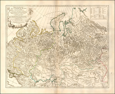
A fascinating Anti-Soviet Propaganda map made while the USSR was briefly allied with Nazi Germany at the beginning of World War II.
This truly curious map was issued as an insert for the Los Angeles Examiner on January 7, 1940. During this time, Russia, or more correctly, the Union of Soviet Socialist Republics, was following a non-aggression accord with Nazi Germany, popularly known as the Molotov-Ribbentrop Pact, signed in September 1939. Nazi Germany was already at war with Britain and France, and while the U.S. was still technically neutral, many Americans both sympathized with the British cause and had a great disdain for Communists (and Joseph Stalin's USSR in particular). This entertaining propagandist piece is strongly in line with these sentiments.
The map's perspective shows the earth from a northeasterly perspective, showing Russia spread out like a spider accross the top of the globe. The map's title, "The Russian Spider Sits Atop the World and Watches for more Victims" captures the sentiment that USSR was a predatory power and threat to global security, at least as much as Nazi Germany. The opening paragraph of the explanation in the upper left reads:
Soviet Russia's wanton attack on Finland is not merely a punative expedtion. It is the prelude to a general expansion that will engulf most of Europe and Asia, and ultimately the world, if not stopped.
The mention of Finland and how it had born the "brunt" of Russia's aggression, refers to the ongoing Winter War, during which the USSR attacked Finland and seized the territory of Karelia. The map warns that "Sweden may be next, along with Norway". It also notes that all of Poland will be swallowed up by the USSR if Germany looses the war (accepting that the USSR and Germany had already annexed and divided Poland between them).
The map includes a pointed warning for Americans, noting "Yonder lies Alaska which Russia regrets she sold to U.S.A", seeking to conjour up the spectre of Russian irredentist sentiment. The map also gives numerous examples of how "The Reds" were inflitrating numerous Asian lands, such as Iran, Afghanistan and China, supposedly as a prelude to weaving them into its web.
As it turned out, Nazi Germany would attack the USSR in the spring of 1941, violating the Molotov-Ribbentop Pact. By the end of that year the US, Britain and her allies would form an awkward allaince with "Uncle Joe's" Soviet Union against Nazi Germany. However, as the map correctly anticipates, once Germany was defeated, America and the West would find themselves in a global contest with the USSR - the Cold War.
The illustrator of the present map, Howard A. Burke, was born in Illinois in 1900. Burke was both illustrator and art critic for the San Francisco Examiner and the Los Angeles Examiner from 1932 to 1940. Howard Burke prepared several maps for the Los Angeles Examiner during WWII, including:
www.davidrumsey.com/luna/servlet/detail/RUMSEY~8~1~263504~5524262
www.davidrumsey.com/luna/servlet/detail/RUMSEY~8~1~221096~5505177
All of Burke's maps are very rare on the market, as they were intended to be discarded.

![[ Europe according to Ptolemy ] Europa nach Ptolemaeos](https://storage.googleapis.com/raremaps/img/small/97254.jpg)
![(Mississippi Bubble) [Complete set of Eight Engravings of Callot Figures from the Mirror of Folly]](https://storage.googleapis.com/raremaps/img/small/94218.jpg)