|
||

|

|
|

|
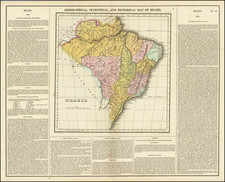
Exceedingly rare and finely executed "blue-back" sea chart of the Brazilian coastline between Cabo Frío and Céara, published in New York by William Hooker and copyrighted 5th day of Jany. 1825.
The main chart extends from the mouth of the Amazon River all the way south to the Cabo Frio, near Rio de Janeiro, and is embellished with wind roses, rhumb lines and soundings to aid navigation. It includes detailed insets of Bahia, the Rio de Janeiro area, Pernambuco and Maranhão.
The chart is based upon surveys conducted under the auspices of the Portuguese Navy around the turn of the century. It is based directly on a British sea chart published under the title "The Brazil Pilot; or a Description of the Coast of Brazil, translated from the Portuguese of Manoel Pimental, Principal Hydrographer to his Majesty, John the Fifth, of Portugal. To which are added, Charts of some of its most considerable Ports, from MSS. never before published," which had been issued circa 1809.
During the first half of the 19th Century, both British and American mariners were making frequent visits to Brazil's ports and sailing along its coastlines. Britain was a longtime ally of Portugal and maintained extensive trade links with ports such as Rio de Janeiro and Bahia. Vessels of the Royal Navy also frequently reprovisioned in Brazil before and after rounding Cape Horn. Meanwhile, American whalers, mainly based in New England, were continually sailing to the South Atlantic and South Pacific Oceans, by way of Brazil. This chart would have been very useful during its time, as it would have been the first accurate general chart of Brazilian waters available to American shipping. As the British had superior access to Portuguese surveys and a more developed chart publishing industry, it was natural for American chartmakers to copy groundbreaking British publications.
The chart is extremely rare and this would appear to be the earliest recorded edition. The UCLA library holds a photocopy of the 1827 edition, which bears the imprint of E & G W Blunt and a later 1840 edition by Blunt is also recorded, both of which do not include any attribution to Hooker. A larger version of the chart was apparently issued by Blatchford in 1830, with profile views and other embellishments.
A great specimen of the early scientific maritime cartography of Brazil and a rare monument to contemporary large-scale chart publishing in America.
![[ Brazil ] Brasilia Lusitanorum in XIV praefecturas divis. Per N. Sanson](https://storage.googleapis.com/raremaps/img/small/97912.jpg)