
The item illustrated and described below is sold, but we
have another example in stock. To view the example which
is currently being offered for sale, click the
"View Details" button below.


|
||

|

|
|

|
Stock# 37632
Description
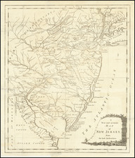
Detailed map of the New Jersey, in the midst of the American Revolution.
The map shows early counties, towns, roads, rivers, islands and other detailed features. Keith's line of 1687 is shown, as is the Division Line of 1743 between East and West Jersey.
While the map is theoretically not rare, this is the first example we have offered in nearly 20 years.
Condition Description
Expertly repaired tear at lower centerfold.
Reference
Jolly Univ 186.


![[Rare First State] Novissima Tabula Regionis Ludovicianae Gallice dictae la Louisiane . . .](https://storage.googleapis.com/raremaps/img/small/72622.jpg)