|
||

|

|
|

|
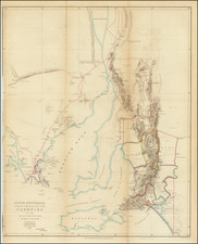
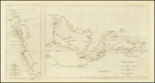
Unrecorded early map of Australia, one of the two appearances of the presumed existence of Bass Strait, reflecting knowledge of the Strait prior to its "discovery" by Matthew Flinders, 1798-1799.
Bass Strait was named after George Bass after he and Matthew Flinders passed through it while circumnavigating Van Diemen's Land (now named Tasmania) in the Norfolk in 1798-99. At Flinders' recommendation the Governor of New South Wales, in 1800, John Hunter, named the stretch of water between the mainland and Van Diemen's Land "Basses Strait". Later it became known as Bass Strait.
The existence of the strait had been suggested in 1797 by the master of the Sydney Cove when he reached Sydney after deliberately grounding his floundering ship and being stranded on Preservation Island (at the eastern end of the strait). He reported that the strong south westerly swell and the tides and currents suggested that the island was in a channel linking the Pacific and southern Indian Ocean. Governor Hunter thus wrote to Joseph Banks in August of 1797 that it seemed certain a strait existed.
The official account of Flinders' voyage appeared in Observations on the Coasts of Van Diemen's Land, published in London in 1801. According to Robert Clancy, there were only two appearances of the "supposed strait" prior to Flinders, the present map and a map by Aaron Arrowsmith, published in 1798.
The existance of this map was unknown to Tooley, although it appears in a Gowrie Galleries Catalog in 1994 (Item 128).
![[ Australia called Notasie ou Nouvelle Hollande ] Carte De L'Oceanie Contenant L'Australe, La Polynesie et Les Iles Asiatique . . . 1838](https://storage.googleapis.com/raremaps/img/small/99649.jpg)