|
||

|

|
|

|
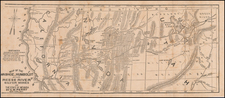
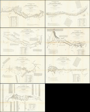
Rare pocket map example of Colton's map of the Southwest.
While at first blush, the map appears similar to Johnson's map of the same period, this map is vastly more detailed. There are many mining districts named and outlined in Southern California. A number of early wagon roads are shown, with United States forts each marked with American flags. The routes surveyed by Emory, Simpson, Albert & Peck, Fremont, Gunnison and others are shown, with years relevant to the survey. The Emigrant's Road, Fredonyers Trail and Pass, Pony Express and U.S. Mail Routes are shown.
A number of mining districts and details are shown in Yavapai County, Arizona Territory. The course of the Gila and its tributaries are significantly revised and Fort McDowell is added (established in 1867), with Fort Whipple, and the Wickenburg, Weaver, Yavapai and Agua Fria Mining Districts. Fort Bowie is also added, as is Camp Riggs and Fort Goodwin (1864-1871).
There is nice detail in Lincoln County, Arizona, unlike earlier editions.
Excellent topographical detail, includes elevations. Many Indian tribes and other interesting places are noted, along with annotations. Includes decorative border.
G. W. & C. B. Colton was a prominent family firm of mapmakers who were leaders in the American map trade in the nineteenth century. The business was founded by Joseph Hutchins Colton (1800-1893) who bought copyrights to existing maps and oversaw their production. By the 1850s, their output had expanded to include original maps, guidebooks, atlases, and railroad maps. Joseph was succeeded by his sons, George Woolworth (1827-1901) and Charles B. Colton (1831-1916). The firm was renamed G. W. & C. B. Colton as a result. George is thought responsible for their best-known work, the General Atlas, originally published under that title in 1857. In 1898, the brothers merged their business and the firm became Colton, Ohman, & Co., which operated until 1901, when August R. Ohman took on the business alone and dropped the Colton name.