|
||

|

|
|

|
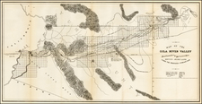
Fine example of this Tract map of Beverly Crest, published by George Read & Company in connection with the sale or residential lots in this Los Angeles subdivision.
Originally known as Wiltfong Canyon or Chinaman Canyon, Beverly Crest was a residential development first undertaken by George E. Read in 1924.
The map depicts the Beverly Crest real estate development, with Tract Office and "entrance gates" to the development accessed via Schuyler Road. The map, using small outline
images, locates some of the "large estates" in the sprawling Beverly Hills acreage adjacent to the development. These include the home of oil baron Kirk Johnson, real estate developer Max Whittier, film star Pauline Frederick, banker and executive Benjamin Meyer, along with the estate of W.F. Schuyler. The Doheny Ranch property is to the east of the new development and the home of Ned Doheny, built by oil baron Edward L. Doheny for his son, is pictured to the north of Doheny Road.
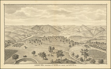
On the verso, a photographic view depicts Beverly Crest nestled in the hills above Sunset Boulevard. The developer George E. Read, Inc. extols "these beautiful half-acre homesites in
the exclusive Beverly Hills district [which] command a panoramic view sweeping from the City of Los Angeles, across the verdant Beverly Valley, to the blue Pacific Ocean and Catalina Island." He goes on to note that "our having successfully developed and sold the exclusive communities, 'Beverly Estates' and 'Beverly Terrace,' is your assurance of satisfaction in dealing with us."
The map includes the following birdseye photo on the verso: /gallery/enlarge/37451a
No records located in WorldCat. An attractive and scarce broadside and real estate map pertaining to one of Los Angeles' most exclusive neighborhoods.