|
||

|

|
|

|
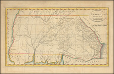
Rare first edition of Anthony Finley's important pocket map of Georgia and the Carolinas, predating all other versions of the map.
This rare pocket map is the earliest edition of Finley's map of North Carolina, South Carolina and Georgia. This separately-issued map preceded the version of the map which appeared in Anthony Finley's New General Atlas (Philadelphia, 1826), which regularly appears on the market. It is an interesting map of the three states that details the counties in transition.
In North Carolina, Haywood county has not yet given up it's western tip to Macon county; Pendleton County in South Carolina will be broken into Anderson and Pickens Counties in 1826; and in Georgia the 1823 creation of Decatur from part of Early County is not yet record on this map.
The Eastern Georgia counties include regions of the Cherokee and Lower Creek Indians and a number of early forts. Includes a large table with topographical tables. Hand colored by counties and showing towns, roads, rivers, lakes, mountains and other geographical and topographical details. The map is a couple of years too early to name Decatur, the first settlement built on Indian lands in the area of today's Atlanta. The lower right portion is filled with a large topographical table giving population by county from the 1820 census for "White, Free Black & Slave Population".
The present example includes its original leather covers, often lacking on period pocket maps. This early pocket map edition is rare, we are aware of only one auction record for the map during the last 25 years.
Anthony Finley (1784-1836) was an American map publisher. Little is known about his life. He is presumed to have been born in Philadelphia, where he also died. A publisher, Finley was also involved in several Philadelphia civic and professional societies such as the Philadelphia Apprentices’ Library. He may have been in business as early as 1809 and his first publication dates from ca. 1811.
His first maps also date from this year, with two maps in Daniel Edward Clarke’s Travels in Various Countries of Europe, Asia, and Africa. The first atlas published by Finley appeared in 1818, the Atlas classica, or, Select maps of ancient geography, both sacred and profane, for the use of colleges and schools in the United States. He is best known for his A New General Atlas Comprising a Complete Set of Maps (1824), which was a bestseller. There were two editions in 1824, with annual editions until 1834.
Finley was part of the first generation of American publishers who produced high quality, precise maps on American soil. He was in competition with other Philadelphia publishers, for example Henry S. Tanner. Finley’s A New American Atlas Designed Principally to Illustrate the Geography of the United States of America (1826) closely mirrors Tanner’s A New American Atlas Containing Maps of the Several States of the North American Union, with similar groupings of maps; the main difference is the smaller scale of Finley’s maps. Finley printed two editions of this atlas.

![[Florida and Gulf Coast] The Coast of West Florida and Louisiana . . . [with] The Peninsula and Gulf of Florida or Channel of Bahama with the Bahama Islands . . .](https://storage.googleapis.com/raremaps/img/small/66344.jpg)