|
||

|

|
|

|
Detailed map of the Berkshires, issued as a promotional map for the Berkshire Life Insurance Company.
Finely executed promotional map, surrounded with some text related to the local Berkshire Life Insurance Co. This noteworthy and seldom seen map was published by Walter Watson for the Berkshire Life Insurance Company of Pittsfield, Mass. The map lays out the railways and highways of the Berkshire Hills region in 1883 in remarkable detail. A legend identifies main roads, school houses, cemeteries, churches, railroad stations, and much, much more.
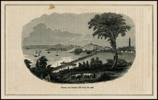
The Berkshire Hills are described at right in a long excerpt from "Taghconic," by J.E.A. Smith. A vignette shows the company's headquarters building and another "View of the Berkshire Hills. Greylock Peak from the south end of Lake Onota." According to the Harvard University Gazette, Oct. 24, 2002, this map is widely regarded as the first 'free' road map ever distributed, mainly for use by touring bicyclists. Beautifully printed by the Sun Printing Company, Pittsfield, Mass.
Includes two vignettes of the Office of Berkshire Life Insurance Co. and the Berkshire Hills. Map shows roads, railroads, drainage, terrain, and major cities. Relief shown by hachures and spot heights. Printed in red in lower right hand corner: "For copies of this map apply to the Berkshire Life Insurance Company of Pittsfield, Mass., or to any of its Agencies in the principal cities of the Northern and Eastern States".

![[ English Plantations in North America ] A New Map of the most Considerable Plantations of the English In America Dedicated to His Highness William Duke of Glocester.](https://storage.googleapis.com/raremaps/img/small/98233.jpg)
![[Salem, Massachusetts] Salem Eine Stadt im Engellandischen America, in der Grafschafft Essex, welche von den Engellandern 1629 erbauet worden, und 2 Havfen hat einen fur den Sommer, und einen fur den Winter](https://storage.googleapis.com/raremaps/img/small/70175.jpg)