|
||

|

|
|

|
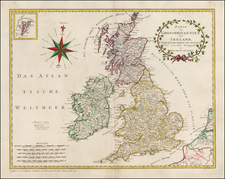
Fine example of the title page from Henry Overton's extremely rare 1743 edition of John Speed's Theatre of Great Britaine, perhaps the most famous and enduring atlas of Great Britain published in the 17th Century.
The map includes allegorical figures showing a Britaine, Roman, Saxon, Dane and Norman, the "ethnic composition" of the people of 17th Century Britain. The plate was originally engraved by R. White, for Thomas Bassett and Richard Chiswell, the last major updated edition of Speed's atlas, but here has been revised for the present edition.
Henry Overton acquired Speed's plates from Christopher Browne in 1713. Hodson records four variants of the Speed Overton Atlas, publishing editions circa 1714, post-1716, circa 1720, and this last edition of 1743.
Hodson only records two complete examples of the atlas: The Cambridge University Library; and the C.A. Burden Collection; the example in the British Library lacks the title-page; and the Sheffield Reference Library lacks maps of Cornwall, Hampshire, Middlesex, Sussex, Yorkshire, and Wales.
The Overton family was a prominent part of the printing, and mapmaking, industry in London in the seventeenth and eighteenth centuries. John Overton (1639/40-1713) was the son of a tailor who apprenticed to Stationer Thomas Gould. He was made free of the Stationers’ Company in 1663. Two years later, London was struck by the Great Plague of 1665-6. Peter Stent, a leading printseller, succumbed and Overton took over his shop. This burned in the Great Fire of 1666, but Overton had rebuilt by 1669, when he advertised his wares from the White Horse on Snow Hill. Overton specialized in prints, portraits, and especially maps and topographical views.
John was likely married three times and had seven children. His eldest, Thomas, emigrated to America. His second oldest, Henry, was executor of John’s will when the latter died in 1713. Henry (1675/6-1751) acquired his father’s stock in 1707 and ran the shop until his own death in 1751. He published many maps, most focusing on the British Isles. His shop and stock passed to his nephew, another Henry, son of John’s fourth son, James.
Henry the Elder’s brother, Philip (ca. 1681-1745), was also a printer and mapmaker. Philip served as his father’s apprentice and was made free of the Stationers’ in 1702. His father set him up in the trade in 1707 and by 1710 he was working from the sign of the Golden Buck in Fleet Street. Philip specialized in fine arts prints, including Hogarth’s Hudibras set (1726), but he also sold many maps. At his death in 1745 he left his shop to his widow, Mary. She ran the shop and then married James Sayer, whose brother, Robert, became Mary’s assistant. He took over the business in 1748 and became a famous purveyor of maps, charts, and views.
Back at the sign of the White Horse, Henry the Younger continued the family business, expanding their stock to include a large collection of landscape views. He often partnered with Robert Sayer. He continued in business until at least 1764, when he drops out of the historical record.