This item has been sold, but you can enter your email address to be notified if another example becomes available.


|
||

|

|
|

|
Stock# 36688
Description
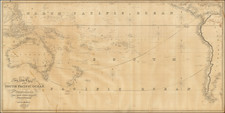
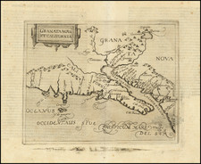
Extremely rare section of a multi-sheet map of the Pacific Ocean, issued by order of the first President of Mexico, Don Guadalupe Victoria.
Fine sea chart of the Pacific coast from Alaska to Panama, including the Hawaiian Islands, and designates coastal cities and other points of interest along the Gulf of Mexico.
As noted by Rumsey, it is likely that only the top two sheets were ever printed, and the western of the two sheets is virtually unobtainable:
First Mexican edition of Espinosa y Tello's chart of 1814. In two sheets, one covering the western coast of America, the other the eastern coast of Asia. The original London edition was in six sheets, and the two sheets of the Mexican edition have borders that suggest another four sheets, although it is not known if they were printed. Map is without color. "Longitude oeste de Cadiz". Emblem with eagle perched on boat surrounded by 2 sails and 2 anchors in lower left corner of the east sheet. Relief shown by hachures. Depth by soundings. Shows routes of Spanish voyages and date of exploration in the Pacific, including the Northwest Coast of North America. Covers northwest coast of America, Kamchatka, Japan, the Philippines, Hawaii & most of Micronesia.
This was apparently the only sheet issued, neither Streeter nor any of the major modern collections, except Rumsey, locates the Eastern sheet of this map.