|
||

|

|
|

|
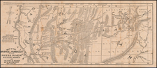
First edition of "the first separate map of Colorado" (Streeter), "Drawn by Frederick J. Ebert under direction of Governor Wm. Gilpin," and published by Jacob Monk in 1862.
The Ebert-Gilpin map of Colorado Territory is perhaps best described by Carl Wheat, who refers to the map as the "first 'indigenous' [Colorado] map of importance ... a truly imposing map, a credit to all who had a hand in it." Wheat further notes that the Ebert-Gilpin is vastly superior to the General Land Office maps of Colorado Territory (dated Denver City, November 1, 1861 and September 1 1862), stating that:
The Ebert-Gilpin map presents Colorado as politically advanced, divided up into seventeen counties besides an 'Indian Reserve' on the Plains. A great many cities and mining camps are located down the length of the Rockies, and the initial surveys of the General Land Office are indicated. Topography is drawn in to an impressive degree, the latest government maps used to great effect. Principal roads are shown, and notable among them is the 'Road to Salt Lake' reconnoitered in 1861 by E.L. Berthoud [the first published appearance of this route on a printed map].
Based upon a letter from Territorial Governor William Gilpin to Secretary of State Seward dated 1862, it would appear that a manuscript version of Gilpin's map was part of a group of maps transmitted by Gilpin to Seward and received in February 1862, although the manuscript map has not been located in any government archive. The map was first published in 1862 in Philadelphia by Jacob Monk (Thos. Sinclair's Lith).
Among early Colorado maps, the Ebert-Gilpin map is without question the finest early map of the Territory, vastly surpassing even the best available government maps. It is quite likely that Governor Gilpin used his position to access information from sources other than the Government Land Office for the preparation of the map. Frederick J. Ebert, a German Forestry Engineer and Railroad Surveyor may also have had some access to information not available to the GLO, but logic suggests that Gilpin was the most likely procuring source. Based upon the Gilpin-Seward correspondence, it would seem clear that the Ebert-Gilpin map of 1862 pre-dates the 1862 GLO Map.
Among its other exceptional features, the Ebert-Gilpin map is the first map of Colorado to show counties and served as the underlying topographical image for every other large Colorado map in the 1860s. It was not until 1871, when GW & CB Colton, H.L. Thayer, and George Cram each created a large new image as an alternative to the Ebert-Gilpin map.
Frederick J. Ebert (1822-1888), who is credited as having drawn the map, was born in Brunswick, Germany on January 27, 1822. After graduating from College, he became a forestry engineer. He held an officer's commision under the Duke of Brunswick during the Revolution of 1848, before coming to America in 1850. He first settled in Milwaukee, before moving to St. Louis and later St. Joseph, Missouri, where he worked as a civil engineer. Ebert came to Colorado in 1860, on a survey team working on the line of the Kansas Pacific Railroad. Shortly after arriving in Denver, Ebert began working for W.A.H. Loveland, where he surveyed a railroad line from Denver to Central City, the first railroad survey undertaken in the Rocky Mountains.
During 1862, Ebert undertook two noteworthy tasks. The first was the drafting of this map of Colorado Territory, which likely commenced in late 1861. Ebert also assisted Surveyor-General John Pierce in making the first land survey of Colorado Territory. In 1863, Ebert became Denver's City Engineer, a position he held for two terms. Following his term as City Engineer, Ebert was primarily engaged in various business and political ventures. He helped to found the first iron rolling mill in Denver and served as president of the board of regents for University of Colorado at Boulder.
The present example includes the name E.T. Wells in three places on the map and verso (the map was acquired from his heirs, having remained in the family for 150 years, until January 2014). Ebenezer T. Wells is probably best known as one of authors of both the Colorado Territorial and State Constitutions and a member of the Supreme Court of both Colorado Territory and the State of Colorado. The map includes over two dozen annotations, including the meticulous addition of a number of boundary lines. Perhaps most interesting among these is the attempt to define the boundary for the short-lived Greenwood County (1870-1874). The manner in which this information has been added, as well as some of the dates on the other annoations, suggest that Wells likely added the annotations between about 1868 and 1869.
A second annotation of note is the inclusion of the boundary in Western Colorado created pursuant to the Ute Indian Treaty of March 2, 1868. The map contains the following manuscript annotations (which appear to be in at least 2 different hands):
- Pike's Stockade 1807-1808
- Ft. Massachusetts [1852-1858]
- Fort Wise (corrected to Lyon, abandoned 1867)
- New Fort Lyon
- Locates the Northern and Eastern Boundaries of the Ute Reservation per Treaty of Novembver 6, 1868
- Locates the Wheat R[iver] and Little (?) R[iver], north and west of near Egeria Park.
- Original Boundary between Territory of Kansas and New Mexico
- Eastern Boundary of the Territory of New Mexico by Act of Sept 9, 1850
- Bunkara River "or Grand R[iver]"
- Boiling Springs shown on the Upper Colorado River (?)
- Mosquito
- Montgomery
- Additional Township and Section details in Pueblo and El Paso Counties.
- Western, Southern & Northern Boundary Lines For Greenwood County (November 2, 1870 to February 6, 1874)
- North and South Boundary for Bent County
- Saguache L. 1867 . . . (showing the establishment of Saguache County from the northern part of Costilla County in 1867)
- New location of Costilla County
- East Point of La Loma Del Norte
- Corner of Huerfano County
- San Carlos (south of Pueblo, Colorado)
- Culabra [River] (southwest of Ft. Massachusetts)
- ??? Ranch (East of Spanish Peaks)
- Rio Chuchuras
- Trinidad
- Several more annotations are more difficult to decipher
The present example of the map includes the inscription "E.T. Wells." Ebenezer T. Wells (1835-1923) came to Colorado with his family in 1865. He became a member of the Territorial Legislative Assembly in the winter of 1866-67, and framed the revision of the territorial statutes known as the "Revised Statutes of 1868." In 1871, he was appointed Judge of the Supreme Court of the Territory of Colorado and (later) of the State of Colorado, before leaving the bench in 1877. Elected a member of the State Constitutional Convention of 1876, he is considered one of the co-authors of the Colorado State Constitution.
The map is known in several states:
- State 1: This example (1862)
- State 2: Reduced size inset map (20 x 15 inches) on Pratt & Buell's Map of the Gold Regions in the Vicinity of Central City Gilpin County . . . (1862)
- State 3: Variant title ( Map of Colorado Territory, Shewing the System of Parks. . . ) (1865; published by Monk)
- State 4: Map of Colorado Territory, embracing the Central Gold Region . . . (GW & CB Colton, 1865)
- State 5: Map of Colorado Territory, embracing the Central Gold Region . . . (GW & CB Colton, 1866)
- State 6: Reduced size map (18.5 x 26 inches ) bound into Blackmore's Colorado: Its Resources, Parks and Prospects . . . (1869)
- State 7: Map of Colorado Territory, embracing the Central Gold Region . . . (GW & CB Colton, 1870)
The map is of the utmost rarity. We are aware of only a single example of the first edition appearing on the market in the past 100 years (Streeter Sale, #2147). Not in the Denver Public Library or Yale/Beinecke Library. The Colorado Historical and Natural History Society Biennial Report of 1908-1910 lists the Society's acquistion of the map, which remains the only example of the map in a Colorado Institution. We also note 2 copies at the Library of Congress (one of which is heavily annotated), along with the Streeter Copy, which is now at the Newberry Library. A recent private census notes only 4 institutional copies (as shown above), one copy in a private collection and this example, which came to light for the first time in January 2014.
A seminal item for Colorado collectors.
![Air Log Western Air Express [Los Angeles-San Diego, Las Vegas-Los Angeles, Milford-Vegas, Salt Lake City-Milford]](https://storage.googleapis.com/raremaps/img/small/85953.jpg)
![Nouvelle Carte Du Mexique, Du Texas Et D'Une Partie Des Etats Limitrophes . . . 1840 [Proposed Railroads In Texas -- First Appearance of Arizona on a Printed Map]](https://storage.googleapis.com/raremaps/img/small/103480.jpg)