|
||

|

|
|

|
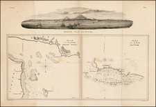
A rare and historically important sea chart from Laurie & Whittle's East-India Pilot, the definitive maritime atlas of East Asia of its era.
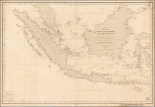
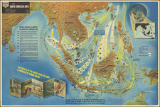
This highly detailed chart embraces most of the South China Sea, then as now, one of the world's busiest shipping corridors. It extends northwards to include the southern coasts of China (including the future site of Hong Kong, foudned in 1841, and the "European Factories" at Canton [Guangzhou], established since 1686), as well as the western coasts of Taiwan and the Philippines. Southwards it details the coasts of Vietnam and Cambodia and the southern tip of the Malay Peninsula (including the future site of Singapore). It also encompasses all of the island of Borneo, and the adjacent coasts of Sumatra and the Celebes.
While the basic template is derived from Dutch (Van Keulen) and French (Mannevillette) charts, the present chart features numerous improvements gained from the observations and surveys of ships employed by the English East India Company (EEC). While the EEC, founded in 1600, had thus far been primarily engaged with trade on the Indian Subcontinent, during the Napoleonic Wars (1795-1815), when this chart was produced, the Company had been aggrevisely expanding its operations into the South China Sea. In 1811, the British seized key areas of modern Malaysia and Indonesia from the Dutch, opening the way to the founding of Singapore by Stamford Raffles in 1819. The British presence in Malaya was made permanent following the Anglo-Dutch Treaty of 1824. Moreover, while European trade with China had since 1757 been technically limited to the port of Canton, beginning with George Macartney's 1793 British embassy to Beijing, the EEC had been working to increase both its sanctioned and illicit trade with the Middle Kingdom. Importantly, the present chart was the defintive map of reocrd used by the EEC and the Royal Navy during this critical period.
On the chart, the seas are crossed with rhumb lines, while inshore areas feature numeorus bathymetric soundings, and the locations of navigational hazards. The labeled and dated tracks of ships traverse the seas, such as the "Track of the Pitt Capt. E. Manning Towards China 1789", indicating some of the sources of the chart's improved hydrographic intelligence. The general perspective is augmented by the inclusion of six profile views and three cartographic insets, based on recent observations.
The chart is one of the most important maps from the 1802 edition of Laurie & Whittle's East India pilot, or, Oriental navigator, first published in 1794. This maritime atlas was the defintive guide for navigation in Eastern Asia during its time, and its charts formed the basis for the subsequent works produced by the likes of William Heather and John William Norie. The firm of Robert Laurie and James Whittle had a priviledged relationship with both the EEC and the Royal Navy, and from the period extending roughly from 1790 to 1810 had special access to the the latest manuscript charts which arrived on ships returning to England from Asia.
The chart rarely appears on the market, especially in such fine condition, and is considered to be an anchor piece for any fine Southeast Asia and China collection.
Robert Laurie (ca. 1755-1836) and James Whittle (1757-1818) formed their Fleet Street, London-based firm upon the 1794 death of their employer Robert Sayer, himself one of the dominant print and mapmakers of the last half of the 18th century.
Laurie & Whittle started managing Sayer's business as early as 1787. They took over all managerial duties when Sayer's health flagged in 1792, and they changed the imprint in 1794 upon his death. Sayer left the two a 21-year lease on the shop (at £100 a year) and on Sayer's Bolt Court premises, as well as an option to acquire stock and equipment at a preferential price of £5,000 payable over three years.
Robert Laurie retired from the firm in 1812, and his role was assumed by his son, Richard Holmes Laurie (1777-1858). The younger Laurie worked with James Whittle until the latter died in 1818. After R. H. Laurie died in 1858, Alexander George Findlay, FRGS (1812-1875) purchased the firm from his daughters. The firm continues today under another name, specializing in yachting charts.
Laurie & Whittle were prolific print and map publishers, and throughout their careers, they produced numerous very important and rare works. They carried on Robert Sayer's atlas business and were responsible for editions of The Complete East-India Pilot and The American Atlas.
![[Southwest Coast fo Myanmar - Myeik and Andaman Sea] Coast of Tenasserim](https://storage.googleapis.com/raremaps/img/small/64783.jpg)