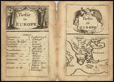
|
||

|

|
|

|
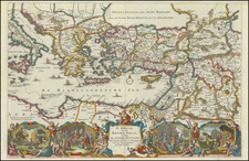
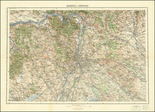
A large-scale map depicting the theater of Great Turkish War (1683-99) in Southeastern Europe, one of the most consequential conflicts of the early modern era.
This highly detailed map embraces much of Southeastern Europe, and is centered horizontally on the Danube River, extending from Vienna in the upper left to Istanbul in the lower right. The map basically showcases the territories that were long contested between thes four great states that lay along the periphery: Habsburg Austria, Poland-Lithuania and Russia to the north, and the Ottoman Empire to the south. Shown here area all or part of several modern day nations, including, Austria, Slovenia, Hungary, Poland, Slovakia, the Czech Republic, Croatia, Serbia, Montenegro, Romania, Bulgaria, Moldova, Ukraine, Greece and Turkey. The view is highly detailed, as the various jurisdictions are distinguished by their own colors, while major, rivers, towns and roads are marked.
The Great Turkish War (1683-1699) marked a turning point in European history. Up to the 1680s, the European Christian powers of Habsburg Austria, Russia, Poland-Lithuania and the Republic of Venice had separately fought the Ottoman Empire in numerous wars over the last century only to arrive at a stalemate. The Turks had largely kept the great gains they had made during the reign of Suleiman the Magnificent (ruled 1520-66), in spite of innumerable attempts by the Christian powers to dislodge them. The line of control generally ran through Croatia, the middle of Hungary and northern Romania to what is now Moldova, with the Ottoman lands being to the south of the line.
In 1683, an Ottoman army broke out of Hungary to besiege Vienna, the Habsburg capital. This sent a shockwave throughout Europe, and only the intervention of Poland's King Jan Sobieski saved the city. In 1684, the region's main Christian powers formed the Holy League, marking the first time that they all joined forces to fight to Ottomans. This quickly turned the tables, as the Allies inflicted a series of severe defeats on the Turks. The Second Battle of Mohács (1687) restored all of Hungary to the Habsburgs. The decisive showdown of the war was the Battle of Zenta (1697) in Serbia, whereby an Allied force under Prince Eugene of Savoy crushed the main army of the Ottoman Sultan Mustafa II. Many of the battles are noted on the map, by symbols of 'crossed swords'.
The Turks sued for peace and the war was concluded at the Treaty of Karlowitz (1699). By the treaty, Austria won all of Hungary, areas in the Balkans and Transylvania; Poland-Lithuania regained Podolia; Russia acquired the key Black Sea port of Azov and Venice acquired Morea and inner Dalmatia. The war was highly consequential in the long run in that is signaled the progressive decline of the Ottoman Empire.
Mortier's map is one of the finest and most details overviews of this turning point in European history.
Pierre, or Pieter, Mortier (1661-1711) was a Dutch engraver, son of a French refugee. He was born in Leiden. In 1690 he was granted a privilege to publish French maps in Dutch lands. In 1693 he released the first and accompanying volume of the Neptune Francois. The third followed in 1700. His son, Cornelis (1699-1783), would partner with Johannes Covens I, creating one of the most important map publishing companies of the eighteenth century.
![Danubii Fluminis (hic ab urbe Belgrado, per Mare Nigrum usq[ue] Constantinopolim defluentis exhibiti) pars infima](https://storage.googleapis.com/raremaps/img/small/91026.jpg)