|
||

|

|
|

|
An interesting separately-published map of Europe and Africa, showing the various colonies and transportation routes, issued on the eve of World War 2.
This colorful map shows Europe with its pre-WW2 boundaries, with an enlarged Germany and radically different borders for Poland. Within a couple of years of this map being issued, North Africa would become a major theatre of war between the British Army and German General Erwin Rommel's 'Afrika Corps'.
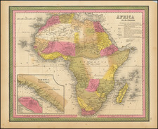
Africa, on the main map, shown from a line running from Angola across to Mozambique northwards, is regionally color-coded to match its colonial master in Europe. Until the 1950s and 1960s virtaully every square inch of the continent was colonized by Europeans, following the 'Scramble for Africa' in the late 19th-century.
As shown on the map, British contolled areas are colored 'Pink', and notably include the "Cape to Cairo" line running down Eastern Africa from Egypt, thorugh Sudan, Uganda, Kenya, Tanganiyka (Tanzania), and Northern Rhodesia (Zambia), and (in the inset, llower left) to include Southern Rhodesia (Zimbabwe) and South Africa. In West Africa, British domains included Nigeria, Gold Coast (Ghana) and Sierra Leone. Much of the expanse of West Africa and the Sahara was under French rule, colored 'Yellow'. The heart of Africa is occupied by the Belgian Congo, colored 'Brown', while the Portuguese colonies of Angola and Mozambique are colored 'Orange'. The Italian colonies of Libya, Eritrea and Abyssinia (Ethiopia) are colored 'Green'.
An interesting feature of the map is the inclusion of major air, sea and land transportation routes connecting the African colonies with Europe. Tables on the left detail vital statistics of the various colonies.