


|
||

|

|
|

|
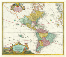
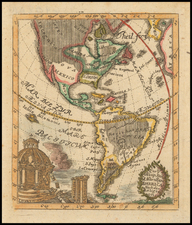
First edition of Johann Baptiste Homann's map of America, showing California as an Island on the second Sanson model and pre-dating Homann's privilege.
The Straits of Anian are shown forming a Northwest Passage between California and the mythical Terra Esonis, which forms a nearly continuous land bridge from the Northwest to Asia. The Pays de Moozemleck is shown east of the Straits of Anian. This landmark remains virtually unchanged through all of Homann's maps of America, despite the transition to a peninsular California, resulting in an odd change from a coastal to an apparently landlocked position for this landmark.
The Great Lakes are shown with some detail. The Mississippi River shows the results of the early French Jesuit explorations, with its sources extending far North of the limits of the maps produced 20 and 30 years earlier, although Le Moyne's mythical lake in the Southeastern United States remains.
The title cartouche is based upon De Fer's landmark map of 1699. The top cartouche is based upon De L'Isle's 1703 map of Canada.
Johann Baptist Homann (1663-1724) was a mapmaker who founded the famous Homann Heirs publishing company. He lived his entire life in Bavaria, particularly in Nuremberg. Initially, Johann trained to become a priest before converting to Protestantism and working as a notary.
In 1702, Johann founded a publishing house that specialized in engravings. The firm flourished, becoming the leading map publisher in Germany and an important entity in the European map market. In 1715, Johann was named Imperial Geographer to the Holy Roman Empire by Charles VI and made a member of the Prussian Academy of Sciences. Most importantly for his business, his reputation and contacts gained him imperial printing privileges which protected his publications and recommended him to customers. Johann is best known for this Grosser Atlas ueber die ganze Welt, or the Grand Atlas of the World, published in 1716.
After Johann died in 1724, the business passed to his son, Christoph (1703-1730). Upon Christoph’s early death, the company passed to subsequent heirs, with the name of the company changing to Homann Erben, or Homann Heirs. The firm continued in business until 1848.
![[The First Maps Printed Color] Cartes en Couleur des Lieux Sujets aux tremblements de Terre Dans toutes les parties du Monde Selon le Sisteme de l’impulsion Solaire](https://storage.googleapis.com/raremaps/img/small/52293op.jpg)
![[ South America ] Carte Encyprotype, de l' Amérique Meridionale . . . 1816 [Wall Map]](https://storage.googleapis.com/raremaps/img/small/69010.jpg)