|
||

|

|
|

|
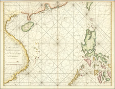
Scarce first edition of this attractive and fascinating late 17th-century map of South and East Asia and Australia, from an early edition of Pierre Mortier's Neptune François.
This fine large-format chart embraces all of South and East Asia, up to the 40th parallel North, including all of the Indian Sub-continent, Indochina, the Malay Peninsula, the Indonesian Archipelago, the Philippines, China and Japan, and importantly shows all of the known discoveries in Australasia.
The cartography is largely based on published Dutch charts that, in turn, were predicated on Dutch East India Company (VOC) sources that had been made public (some VOC charts remained strictly secret). The outline of India is reasonably accurate, and the subcontinent is divided into numerous kingdoms and principalities. Those regions in Northern India are shown to be part of the Mughal Empire, then ruled by the mercurial Emperor Aurangzeb.
The outlines of the Malay Peninsula and Indochina are quite well assured, being based not only on Dutch sources but the mapping done by the 1685 French embassy to Siam (Thailand), undertaken by the Chevalier de Chaumont and François-Timoléon de Choisy.
Most of the Indonesian Archipelago is well charted, however, the mapping of New Guinea is most intriguing. What is actually a large single island is shown here to ambiguously be two separate islands, "Ile de Papous" and "Nouvelle Guinée". This is due to the fact that the island had only been explored partially, and in a piecemeal fashion over the previous two centuries. The western area, Papua, had been sighted in 1526-7 by the Portuguese explorer Jorge de Meneses. In 1545, the Spaniard Íñigo Ortíz de Retes sailed along the north coast of New Guinea as far as the Mamberamo River near which he landed, naming the island "Nueva Guinea". In 1605-6, the Dutch explorer Willem Janszoon explored much of the southern coast of the island. In 1606 Luís Vaz de Torres also explored the southern coast of New Guinea from Milne Bay to the Gulf of Papua. As the mapping and reports from these various expeditions were not freely disseminated, let alone integrated, it is understandable that the depiction here is a composite conception.
The portrayal of Australia and New Zealand is significant for being an overview of what was known of the region by Europeans up to the end of the 1600s. As shown, both on the main map and in the inset, the coastlines of Western Australia and Northern Australia, save for a few blind spots, are reasonably well charted, having been visited on several occasions throughout the century by VOC mariners. The dates of various Dutch landings on these coasts are labeled on the map. The shorelines of the Gulf of Carpentaria and western coast of Queensland's York Peninsula are based on Willem Janszoon's discoveries in 1605. The fragmentary depictions on Tasmania and New Zealand in the inset are based on mapping done during Abel Tasman's voyages from 1642 to 1644.
Further north, the Philippines are reasonably well mapped for the time, as are the coasts of Southern China. While Korea is correctly shown to be a peninsula, the mapping of Korea and Northern China reveals the scarcity of French and Dutch sources in that region. Conversely, much of Japan (Honshu, Shikoku and Kyushu) are reasonably well mapped based on the direct Dutch acquaintance of these islands due to their links with the port of Nagasaki (a Dutch trading base since 1639). Curiously, the area to the north of Honshu, where Hokkaido should be located, is left entirely blank, as no Europeans were known to visit the region until 1734.
Pierre Mortier (1661-1711) was one of the most important map publishers of his time. Born in Leiden, Holland, but of French Huguenot decent, he managed to gain the rights to republish many important French maps and atlases in Amsterdam. This occurred at the very time that the French assumed the global lead in cartography publishing. The present map is from Mortier's edition of the
Neptune François, considered to be the finest sea atlas of its time. It was first issued in Paris by Alexis-Hubert Jaillot in 1693. Following his death, Pierre's business was taken up by his son, Conelius Mortier, who in 1721 formed a lucrative partnership with Johannes Covens. The resulting firm, Coven & Mortier remained in business until 1866.
Pierre, or Pieter, Mortier (1661-1711) was a Dutch engraver, son of a French refugee. He was born in Leiden. In 1690 he was granted a privilege to publish French maps in Dutch lands. In 1693 he released the first and accompanying volume of the Neptune Francois. The third followed in 1700. His son, Cornelis (1699-1783), would partner with Johannes Covens I, creating one of the most important map publishing companies of the eighteenth century.

![[ Dalai Lama ] Grand Lama](https://storage.googleapis.com/raremaps/img/small/97873.jpg)
![(First State!) [ India ] Tabula Asiae X](https://storage.googleapis.com/raremaps/img/small/94639.jpg)