


|
||

|

|
|

|
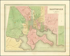
First edition of Bradford's City map of Baltimore, one of the earliest obtainable maps of the City and the first appear in a Commercial Atlas.
The map is colored by wards. Shows streets, early rail lines, wharfs, public buildings, Baltimore College, a Battle Monument, City Dock, Fort McHenry, a lighthouse and a number of other fine details.
Bradford's atlas was a departure from other atlases of the period. Along with HS Tanner, Bradford produced an elegant, well engraved large format atlas on high quality paper. The 1830s were a fascinating transitional period in the US and in domestic cartographic publishing. Bradford's work is without question an important part of this era. The maps were engraved by GW Boynton or S.Stiles, Sherman & Smith.
The first edition is the only edition in outline color. Beginning later in 1838, Bradford obtained a co-publisher in New York and the atlas was thereafter issued in full wash color.
Thomas Gamaliel Bradford (1802-1887) was an American geographic publisher. He hailed from Bradford, Massachusetts and began his publishing career by working for the America Encyclopedia. Then, he edited and republished the Atlas Designed to Illustrate the Abridgement of Universal Geography, Modern & Ancient, which had originally been offered in French by Adrian Balbi. In 1835, he published another atlas, A Comprehensive Atlas: Geographical, Historical & Commercial, and, in 1838, An Illustrated Atlas Geographical, Statistical and Historical of the United States and Adjacent Countries. His interests were primarily in educational publishing and he was one of the first mapmakers to show Texas as an independent country.