
The item illustrated and described below is sold, but we
have another example in stock. To view the example which
is currently being offered for sale, click the
"View Details" button below.


|
||

|

|
|

|
Stock# 35986
Description
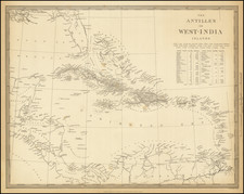
Detailed map of the whole of the West Indies, colored by territorial possession, with a table showing sizes and populations of the various islands.
The Society for the Diffusion of Useful Knowledge was active from the 1830s through the 1860s and published some of the best regional maps of the era.
Condition Description
Minor foxing
![Indigotoire [Indigo Plantation]](https://storage.googleapis.com/raremaps/img/small/92080.jpg)
![The Coast of Newfoundland From Plancentia to Cape Bonavista [and] A Draught of the River Plata in South America [and] Havana, Harbour [and] the Bay of Honda](https://storage.googleapis.com/raremaps/img/small/38599.jpg)

![[ British Colonies in North America & Caribbean ] L'Amerique Angloise, ou Description des Isles et Terres du Roi d'Angleterre dans l'Amerique, Avec de nouvelles Carte de chaque Isle & Terres](https://storage.googleapis.com/raremaps/img/small/102812.jpg)
