


|
||

|

|
|

|
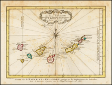
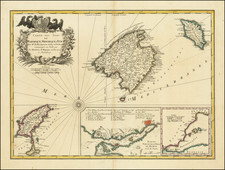
Nice example of Ortelius' map of the Azores, one of the most important destinations of explorers and early commercial mariners in the 16th Century. The size and detail of the map reflects the strategic importance of the Azores during the 16th Century and the level of commercial and navigational activity on the islands.
While known to Europeans in the 14th Century and shown in the
Catalan Atlas, the Azores were not "re-discovered" until the early part of the 15th Century. The Portuguese navigator Diogo de Silves, provided the first reliable account of a contact with the islands of Santa Maria and Sao Miguel in 1427, and Goncalo Vehlo Cabral provides an account of his landing on the island in 1432. The first modern colonization of the island occurred in 1439.
The Azores played a major role in crossings of the Atlantic from the earliest exploration. Columbus stopped in the Azores in 1493 and was briefly arrested as a pirate, until the legitimacy of his voyage was established. The strategic importance of the Island is evidenced by the repeated Spanish attempts to take the island by King Phillip II, and was the last part of the Portuguese empire (other than Macau) to resist his reign. During the Spanish occupation, the islands were a major port of call for the Spanish Galleon trade.
Marcel Van Den Broecke credits Luis Teixeira's single sheet map of Terçera from 1582, which bears Ortelius' name, as the primary source for the map. Meurer mentions one copy at the Bibliotèque Nationale in Paris and a copy in the city library of Cologne and a later manuscript map of the whole group of islands, to which Teixeira subsequently devoted an atlas.
The map was first issued in an edition of 100 examples in the
Additamentum, to the 1583 edition of Ortelius'
Theatrum Orbis Terrarum, which is widely referred to as the first modern atlas and a landmark in the history of Western map making. Beginning in 1570, Abraham Ortelius and his successors published (and continuously added to) this monumental work for a period of over 40 years (not including the very rare edition of 1641), with text on the verso in Latin, Italian, German, Dutch, French, Spanish and English.
Abraham Ortelius is perhaps the best known and most frequently collected of all sixteenth-century mapmakers. Ortelius started his career as a map colorist. In 1547 he entered the Antwerp guild of St Luke as afsetter van Karten. His early career was as a business man, and most of his journeys before 1560, were for commercial purposes. In 1560, while traveling with Gerard Mercator to Trier, Lorraine, and Poitiers, he seems to have been attracted, largely by Mercator’s influence, towards a career as a scientific geographer. From that point forward, he devoted himself to the compilation of his Theatrum Orbis Terrarum (Theatre of the World), which would become the first modern atlas.
In 1564 he completed his “mappemonde", an eight-sheet map of the world. The only extant copy of this great map is in the library of the University of Basel. Ortelius also published a map of Egypt in 1565, a plan of Brittenburg Castle on the coast of the Netherlands, and a map of Asia, prior to 1570.
On May 20, 1570, Ortelius’ Theatrum Orbis Terrarum first appeared in an edition of 70 maps. By the time of his death in 1598, a total of 25 editions were published including editions in Latin, Italian, German, French, and Dutch. Later editions would also be issued in Spanish and English by Ortelius’ successors, Vrients and Plantin, the former adding a number of maps to the atlas, the final edition of which was issued in 1612. Most of the maps in Ortelius' Theatrum were drawn from the works of a number of other mapmakers from around the world; a list of 87 authors is given by Ortelius himself
In 1573, Ortelius published seventeen supplementary maps under the title of Additamentum Theatri Orbis Terrarum. In 1575 he was appointed geographer to the king of Spain, Philip II, on the recommendation of Arias Montanus, who vouched for his orthodoxy (his family, as early as 1535, had fallen under suspicion of Protestantism). In 1578 he laid the basis of a critical treatment of ancient geography with his Synonymia geographica (issued by the Plantin press at Antwerp and republished as Thesaurus geographicus in 1596). In 1584 he issued his Nomenclator Ptolemaicus, a Parergon (a series of maps illustrating ancient history, sacred and secular). Late in life, he also aided Welser in his edition of the Peutinger Table (1598).