|
||

|

|
|

|
Stock# 35646rd
Description
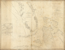
Detailed sea chart of South Florida, the Bahamas, Cuba, Jamaica, Cayman Islands, Puerto Rico, Santa Domingo and the part of the Yucatan Peninsula, published by the Depot De La Marine in the 10th year of the French Republic (An X).
The chart is one of the most detailed maps of the region and is based upon Spanish Charts prepared in the immediately preceding years.
The chart includes coastal features, soundings, shoals, Islands and other details.
Condition Description
Restoration to the lower right corner.
![(Coast of Florida, Georgia and the Carolinas] [To The Members Of The Nautical Institution And Ship-Masters' Society Of The City Of New York, This Chart, Extending From Lat. 40°15 N., Long. 72°15 W., to Lat. 22°35 N., Long. 80°25 W., Is Respectfully Dedicated / By Their Obedient Servant Edmund M. Blunt]](https://storage.googleapis.com/raremaps/img/small/77294.jpg)
![[Mexico and Central America with Baja California inset, from Generalkarte von Nord America samt den Westindischen Inseln Versasst von Herrn. Pownall . . . MDCCLXXXVIII]](https://storage.googleapis.com/raremaps/img/small/95064.jpg)
![[ Gulf Coast & West Coast of Florida ] De Cust van Westindien Van La Desconoscida, tot C. Escondido. . .](https://storage.googleapis.com/raremaps/img/small/65741.jpg)