


|
||

|

|
|

|
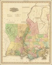
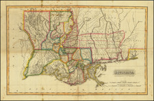
Unrecorded (?) variant edition of this fine separately issued map of Louisiana and Mississippi, published by H.S. Tanner.
Originally published for Tanner's New American Atlas, this map was periodically revised and re-issued, although these later editions are very rare on the market.
Tanner's map is one of the best large format American maps depicting this region in the first half of the 19th Century. Hand Colored by counties, the map shows towns, Indian Villages, roads, topographical details, rivers, lakes, swamps. etc. Includes 5 detailed annotations. One of the best commercial maps of the region published during this period.
The 1839 date is of some significance. Rumsey notes that in 1839, Tanner issued the final edition of his New American Atlas, with the title page and most of the maps dated 1839. A quick comparison of our map to the early editions and to the 1845 edition suggests that there are differences in county configurations and other information, but we could not get high resolution access to an 1845 edition to make a closer study.
OCLC locates 1 example of the 1839 and 1 example of the 1845 edition of this map, but no 1838 edition. Philips lists only the 1839 edition in the Library of Congress.
![Charte von Den Vereinigten Staaten von Nord-America nebst Louisiana . . . 1805 [Rare 1st State of Gussefeld's Louisiana Purchase Map]](https://storage.googleapis.com/raremaps/img/small/63496.jpg)