|
||

|

|
|

|
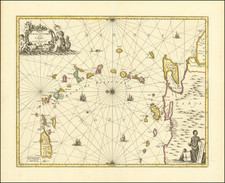
Striking map of Cuba, the southern tip of Florida, the Cayman Islands, Jamaica, Hispaniola and part of the Bahamas, including Guanahani or St. Salvador, the island upon which Columbus is believed to have first landed.
The map was used to illustrate the Dutch translations of the account of the first voyage of Columbus. The cartouche includes Columbus's portrait.
Vander Aa was one of the most prolific compilers of information on the early explorations to America, Asia and Africa. In total, the work reached 130 narratives, which were offered in 28 8vo volumes.
A finely executed copper plate engraving with decorative cartouche.
Pieter van der Aa (1659-1733) was a Dutch mapmaker and publisher who printed pirated editions of foreign bestsellers and illustrated books, but is best known for his voluminous output of maps and atlases. Van der Aa was born to a German stonecutter from Holstein. Interestingly, all three van der Aa sons came to be involved in the printing business. Hildebrand was a copper engraver and Boudewyn was a printer.
![Amer. Sep. No. 69. Porto-Rico [and the Virgin Islands]](https://storage.googleapis.com/raremaps/img/small/42102.jpg)
![Indigotoire [Indigo Plantation]](https://storage.googleapis.com/raremaps/img/small/92080.jpg)