|
||

|

|
|

|
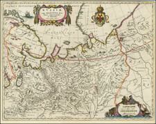
Rare Russian map commemorating the construction of the Trans-Siberian Railway, Nicholas II's Embassy to Japan and Grand Tour inspecting progress of the construction of the Trans-Siberian Railway and displaying the Arctic explorations of Nordienskold and Nansen.
This monumental map was issued by the Cartographical Institution of the Military and Topographical Department of the General Staff of the Russian Army in St. Petersburg. The map is based on the cartography devised by the department's chief, Major General E. A. Koversky. With brilliant chromolithographic color and elaborate detail explained by a detailed legend, this composition captures the vast Asian domains of the Russian Empire at an especially critical time in Russian and Asian history. The purpose of the map was likely both to illustrate the great progress made toward completion of the Trans-Siberian Railway and more generally as a propaganda tool attempting to bolster national pride at a time when Russia was on the verge of anti-Czarist Revolution.
Towards the end of the 19th Century, Russia faced numerous foreign challenges to its interests in the Far East, which with no overland fixed link was a journey of at best many weeks from Moscow. The vast distances also hindered economic development in Siberia, which was exceedingly rich in natural resources. Czar Alexander III decided that the nation would commit itself to building what would be by far the world's greatest feet of engineering - the construction of a Trans-Siberian Railroad from Moscow to Vladivostok on the Pacific Ocean.
To instigate the project and to inspire patriotic fervor, in 1890, the Tsarevich (from 1894 Czar Nicholas II) embarked on a grand tour, sailing through the Suez Canal on an embassy to Japan, before arriving at Vladivostok. From there he began a long overland journey through Siberia back towards Moscow. Along the way, he supervised the early stages of construction of the Trans-Siberian Railway, which from 1891, was being built simultaneously at various points. The intermittent green line follows his route on the map.
During the same period, Major General Koversky's military engineers were surveying the intended route, linking the various existent geodetic surveys that had already been conducted, with the objective of producing an accurate scientific national map. The detailed "Légende", or key at the bottom of the map is supplied in French, as the Russian engineers were heavily influenced by French topographical conventions and wished to remain loyal to this system. As indicated on the map and explained in the Legend, various colors show the areas that had already been surveyed by 1900, although this process would continue intensively until World War I.
The Legend also details the routes of recent voyages of exploration across Siberia, both by Russian (with solid green lines) and foreign (solid red lines) parties, as well as important recent voyages in the Arctic Ocean (shown with pink lines). These include the expedition of Nils Adolf Erik Nordenskiöld aboard the Vega in 1878-9, which was the first successful navigation of the Northeast Passage. Also shown is the attempt of Fridtjof Nansen's Fram expedition to reach the North Pole in 1893-6, including the most northerly point they achieved at 86'14".
The map also details the locations of various settlements, different types of mines and topographical features such as the Taiga (tundra), and various manmade aspects such as the locations of churches, naval ports and even the Great Wall of China.
By the time that this map was issued in 1900, much progress had been achieved on the Railway. A route from Vladivostok through Manchuria (which was under Chinese sovereignly, but politically controlled by Russia) would be completed by 1904, however, the complete line running entirely through Russian territory would not be finished until 1916. Once completed, the Trans-Siberian Railway would extend 5,753 miles, making it by far the longest railway in the world, a distinction it still holds to this day. The railway would span seven time zones and it would take eight days to make the transit from Moscow to Vladivostok.
This map, issued by the Imperial Russian Government, is also a fabulous piece of Czarist propaganda. Issued not long before the 1905 Rebellion, the regime was eager to quell popular dissent by showcasing the dramatic economic progress that the Tran-Siberian Railway promised. The map is surrounded on three sides by finely lithographed registers containing scenes of commerce and prosperity, surmounted by a symbolic scene of Russian youth before the imperial Double-Headed Eagle.
We have dated the map as circa 1896 because it shows Nansen's expedition in the Arctic, but also references Nicholas II as the Tsarevitch, who took the throw in November 1894.
The present map is one of the most highly detailed and fabulously decorative depictions of the Russian Empire in Asia during the twilight of the Romanov Dynasty.
The map is of the utmost rarity. We located no examples of the map in OCLC or on line and only a single later 4 sheet map by Koversky.
![[Iran & Iraq] Quinta Asie Tabula](https://storage.googleapis.com/raremaps/img/small/75299.jpg)