


|
||

|

|
|

|
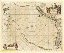
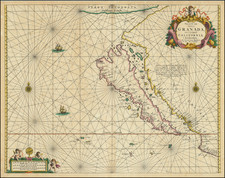
Fine example of Jansson's sea chart of the Pacific, the first chart of the Pacific to show California as an Island and the earliest sea chart of the Pacific to appear in a Dutch Atlas.
A long chain of islands appear in the South Pacific, which are likely a vestige of Terra Australis by are noted by Jansson to have been discovered by Hernando Gallego in 1576.
California is an island, based upon the Briggs model, but lacking the 2nd Punta de la Concepcion suggesting reliance upon Goos or his sources. The large Terra Incognita in the Northwest nearly connects Asia with the Island of California, separated only by the Fretum (Strait) Anian.
Many place names in California.
The present example is an unusually nice example printed on thick paper, which does not include the usual browning and "show through" of the printed text on the verso, as is the case with some many examples of this map.
Jan Janssonius (also known as Johann or Jan Jansson or Janszoon) (1588-1664) was a renowned geographer and publisher of the seventeenth century, when the Dutch dominated map publishing in Europe. Born in Arnhem, Jan was first exposed to the trade via his father, who was also a bookseller and publisher. In 1612, Jan married the daughter of Jodocus Hondius, who was also a prominent mapmaker and seller. Jonssonius’ first maps date from 1616.
In the 1630s, Janssonius worked with his brother-in-law, Henricus Hondius. Their most successful venture was to reissue the Mercator-Hondius atlas. Jodocus Hondius had acquired the plates to the Mercator atlas, first published in 1595, and added 36 additional maps. After Hondius died in 1612, Henricus took over publication; Janssonius joined the venture in 1633. Eventually, the atlas was renamed the Atlas Novus and then the Atlas Major, by which time it had expanded to eleven volumes. Janssonius is also well known for his volume of English county maps, published in 1646.
Janssonius died in Amsterdam in 1664. His son-in-law, Johannes van Waesbergen, took over his business. Eventually, many of Janssonius’ plates were sold to Gerard Valck and Pieter Schenk, who added their names and continued to reissue the maps.
![[ Cook's Discoveries in Russian America ] Chart of the NW Coast of America and the NE Coast of Asia explored in the Years 1778 & 1779 . . .](https://storage.googleapis.com/raremaps/img/small/68831.jpg)