


|
||

|

|
|

|
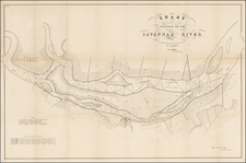
Rare 1838 map showing the plan for the defences proposed by General Gaines in February 1838.
The map shows the Indian Lands, west of the Mississippi River, setting forh the location of the major western forts on the American Frontier. The map is based upon surveys conducted by Washington Hood, shortly before his death. Shows area to the west of the Mississippi, from Fort Snelling to the Gulf of Mexico.
This map was issued as part of the continuing debate over the nature of the Frontier Defenses between the Mississippi River and the Rocky Mountains. General Edmund P. Gaines, one of the most visionary military men of the 19th Century, submitted a plan calling for a system of military railroads that would permit the rapid movement of troops, not only between St. Louis and the frontier, but between Atlantic coastal forts and western frontier forts. In the 1830's this was a revolutionary idea, as railroads were in their infancy with only a few local lines connecting eastern cities.
The map depicts the United States territory west of the Mississippi River, including lands making up present-day Louisiana, Arkansas, Missouri, and the Indian nations bordering them to the west. Lands claimed and ceded by various Native American tribes, and lands assigned to tribes are indicated, as well as proposed forts and railroads. This map is part of a series, together with those illustrating the proposals of J.R. Poinsett and Charles Gratiot, which provide a fascinating comparison of the region, locating many military forts and outposts from Ft. Jessup to Ft. Snelling. The map is uncolored except for red marking the locations of the forts.
The map is considerably rarer than the earlier maps of Poinset and Gratiot.
David H. Burr studied law, passing the New York Bar Exam, and then surveying under Simeon DeWitt in New York. His first atlas was an atlas of New York State (1829), the second state atlas to be issued in the US (after Mills’ Atlas of South Carolina in 1826). In the 1830s, he served as the official topographer for the US Post Office, producing a series of rare and highly sought-after large-format state maps. He also created a map of the country’s postal routes, which features roads, canals, and railroads. Burr traveled to London to work with John Arrowsmith; together, they produced the American Atlas in 1839.
Upon his return to the States, Burr was appointed as a draftsman for the House of Representatives, where he worked until ca. 1841. He later worked for the Louisiana Survey and the Florida Survey. By 1850, he was back in Washington D. C., working on the census. In 1852, the Senate named Burr as the draftsman to compile maps from the Federal Surveys. In 1853, Burr traveled to San Francisco, perhaps as part of his work for the Senate. He was then named as the Surveyor General of Utah in 1855. However, he was unpopular there and returned to Washington D. C. by 1870. Burr is widely regarded as one of the most important names in the nineteenth-century American history of cartography.
![Comparative Size of Lakes and Islands [Great Lakes, Cuba, Formosa, Ireland, Sicily, Cyprus, Vancouver, Sandwich Islands, Puerto Rico, Corsica, Sardinia, Balearics, Malta, etc]](https://storage.googleapis.com/raremaps/img/small/92574.jpg)
![La Florida [with] Guastecan [with] Peruviae Auriferae Regionis Typus](https://storage.googleapis.com/raremaps/img/small/84003.jpg)

![[ Hungarian Traveler In the California and the West with a Comanche and Wichita to Hungarian vocabulary ] Levelei Éjszakamerikából -- Tizenkét eredeti rajzok után készült kő- és egynéhány fametszettel. Közli Prépost István (Letters from North America)](https://storage.googleapis.com/raremaps/img/small/98502.jpg)