|
||

|

|
|

|
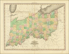
Nice example of Lewis Beck's important early map of Missouri and Illinois, one of the earliest obtainable maps of the two states.
Beck's map provides a remarkable snapshot of Missouri and Illinois, shortly after each obtained statehood. The map includes excellent detail in the settled regions of each state and shows the extent of the Government Land Office Surveys and the unsurveyed regions. Fort Dearbord is shown, but not Chicago, with the land surveys following the course of the Des Plains River. The Military Bounty Lands are shown in Illinois and north of the Missouri River.
In describing the map, Thomas Streeter noted:
the map, on the fairly large scale of 24 miles to the inch, is the first map of either state on such a large scale. The rare Van Zandt map of the Military Lands is on a scale of 4 miles to the inch but that map is only of an almost uninhabited district and not of the whole state.
In the Geographical Memoir to his New American Atlas, Henry Tanner lists Beck's map as a source for his Map of the States of Illinois and Missouri, noting that "This is a very accurate map, from which I obtained most of the county divisions in the latter state."
The map appeared in Beck's A Gazetteer of the states of Illinois and Missouri, containing a general view of each state, a general view of their counties, and a particular description of their towns, villages, rivers, &c., one of the earliest American books describing in detail the Illinois settlement and the adjacent country west of the Mississippi" as noted by Howes. The large folding map covers both Illinois and Missouri.
The Beck map is very rare on the market. While the Gazetteer appears periodically (it made $400 at the Streeter Sale in 1967), this is the first time we have ever seen the map offered for sale.