


|
||

|

|
|

|
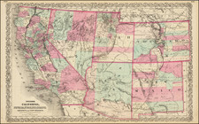
Scarce example of Colton's map of the Southwest, with extensive updates after 1866 in Arizona.
Nevada is truncated at the bottom, so that Las Vegas is in Arizona. Utah is wider than its final configuration. Arizona with only 4 counties. While at first blush, the map appears similar to Johnson's map of the same period, this map is vastly more detailed. There are many mining districts named and outlined in Southern California. A number of early wagon roads are shown, with US Forts each marked with American Flags. The routes surveyed by Emory, Simpson, Albert & Peck, Fremont, Gunnison, and others are shown, with years relevant to the survey. The Emigrant's Road, Fredonyers Trail and Pass, Pony Express and U.S. Mail Routes are shown.
In this edition of the map, a number of new mining districts and details are added in Yavapai County, Arizona Territory. The course of the Gila and its Tributaries are significantly revised and Fort McDowell is added (established in 1867), Fort Whipple, and the Wickenburg, Weaver, Yavapai and Agua Fria Mining Districts. Fort Bowie is also added, as is Camp Riggs and Fort Goodwin (1864-1871).
Excellent topographical detail, includes elevations. Many Indian Tribes and other interesting places are noted, along with annotations. Includes decorative border. .
G. W. & C. B. Colton was a prominent family firm of mapmakers who were leaders in the American map trade in the nineteenth century. The business was founded by Joseph Hutchins Colton (1800-1893) who bought copyrights to existing maps and oversaw their production. By the 1850s, their output had expanded to include original maps, guidebooks, atlases, and railroad maps. Joseph was succeeded by his sons, George Woolworth (1827-1901) and Charles B. Colton (1831-1916). The firm was renamed G. W. & C. B. Colton as a result. George is thought responsible for their best-known work, the General Atlas, originally published under that title in 1857. In 1898, the brothers merged their business and the firm became Colton, Ohman, & Co., which operated until 1901, when August R. Ohman took on the business alone and dropped the Colton name.
![Index Map of the Civil Code of California Designed and Executed By Curtis Lindley . . . [bound into] Revised Laws of the State of California; In Four Codes: Political, Civil, Civil Procedure and Penal . . .](https://storage.googleapis.com/raremaps/img/small/84298.jpg)
![[First California Wine Making Image] The Vintage In California -- At Work At The Wine Presses](https://storage.googleapis.com/raremaps/img/small/89054.jpg)
![Carte De La Louisiane Et Du Cours Du Mississipi . . . Juin 1718 [1st State!]](https://storage.googleapis.com/raremaps/img/small/59797.jpg)
![[ Upper California, Texas and Mexico ] Carte Generale Du Mexique Ed Des Provinces-unies De L'Amerique Central ou Guatemala](https://storage.googleapis.com/raremaps/img/small/81604.jpg)
